
Pricing Change
New pricing for orders of material from this site will come into place shortly. Charges for supply of digital images, digitisation on demand, prints and licensing will be altered.
Glenkindie House


Souterrain (Prehistoric)
Site Name Glenkindie House
Classification Souterrain (Prehistoric)
Alternative Name(s) Glenkindie House Policies; Glenkindie
Canmore ID 17151
Site Number NJ41SW 2
NGR NJ 4191 1433
Datum OSGB36 - NGR
Permalink http://canmore.org.uk/site/17151


- Council Aberdeenshire
- Parish Towie
- Former Region Grampian
- Former District Gordon
- Former County Aberdeenshire
NJ41SW 2 4191 1433.
(NJ 4191 1433) Erd House (NR)
OS 6" map, Aberdeenshire, 2nd ed., (1902)
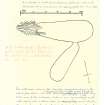
A double-chambered earth-house was found in 1817 on aknoll covered by a cairn, about 800 yards from the River Don.
When discovered, the main gallery, 33 1/2ft long, curved so that the entrance faced E or NE but in 1888 the gallery had been reduced to 22ft in length, the entrance facing SE.
The two galleries were 5 1/2 to 6 1/2ft high and 6 to 9 1/4ft wide, with a smoke-hole in the roof of the side gallery.
Although cleared out, no finds are recorded.
R Thomson 1888; A Mitchell 1863.
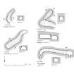
Souterrain as described and planned, except that there is no trace of a covering cairn.
Visited by OS (R L) 26 August 1968.
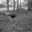
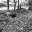
(Name cited as Glenkindie). This curved souterrain is situated on a wooded knoll at an altitude of 250m OD.
[GRC ground photography and 1930's photographs from the collection of Dr John Johnstone cited].
NMRS, MS/712/46.
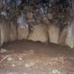
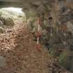
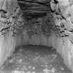
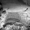
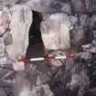
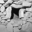
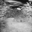
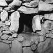
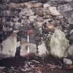
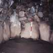
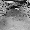
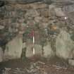
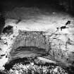
A well-preserved souterrain is situated beneath a clump of trees on a narrow SE-facing terrace 340m WSW of Glenkindie House (NJ41SW 16.00). The souterrain comprises two chambers or passages, the northern of which is entered from the main passage by way of a narrow, original opening set towards the W end of the N wall. The original entrance to the main passage lay at its ESE end but is no longer visible; it was apparently visible in 1817 when the souterrain was discovered, but at that time the passage extended for at least a further 3m eastwards, curving slightly towards the NE. The end of the passage and details of the entrance probably still survive buried beneath a ramp of earth that drops down to the floor of the souterrain from a hole in the roof.
The passage is aligned roughly ESE and WNW, and was originally about 10m long. Only 7m is now visible, and this measures up to 2.7m in breadth and 1.8m in height. The walls are constructed of random rubble masonry set on a basal course of large upright boulders, some of which measure over 1m in height. Above the basal course, the interstices of which have been carefully chocked with small stones, the dry-stone wall has a pronounced corbel, at one point reducing the width of the passage from 2.7m at ground-level to 1.9m at roof-level. The roof has been constructed of large irregularly-shaped slabs and stones, the largest of which measures 1.5m in breadth and is probably at least 2.5m in length, and the gaps between them have been filled with smaller slabs.
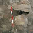
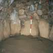
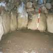
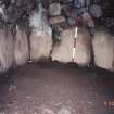
Situated 1.6m from the WNW end, and set about 0.6m above the floor-level, there is the entrance to the chamber on the N. This entrance is defined by three large stones (two jambs and a lintel) and now measures about 0.75m in height by 0.5m in width and 0.6m in length. There is evidence, however, to suggest that this entrance originally had a sill-stone also, in which case it probably measured no more than 0.6m in height.
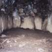
The N chamber measures 5m in length by up to 1.9m in breadth and 1.9m in height. The floor level is flush with the bottom of the entrance and is at least 0.6m above that of the main passage. The construction of the walls and roof is similar to that of the main passage and there is no evidence for the smoke-hole claimed by Mitchell.
Visited by RCAHMS (JRS), 14 October 1997.
A Mitchell 1863.
Scheduled as Glenkindie House, souterrain.
Information from Historic Scotland, scheduling document dated 19 November 2003.
Field Visit (29 July 1943)
This site was recorded as part of the RCAHMS Emergency Survey, undertaken by Angus Graham and Vere Gordon Childe during World War 2. The project archive has been catalogued during 2013-2014 and the material, which includes notebooks, manuscripts, typescripts, plans and photographs, is now available online.
Information from RCAHMS (GF Geddes) 4 December 2014.

