
Pricing Change
New pricing for orders of material from this site will come into place shortly. Charges for supply of digital images, digitisation on demand, prints and licensing will be altered.
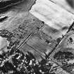
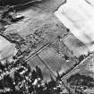
Tomnaverie


Cairn(S) (Period Unassigned), Field Boundary(S) (Period Unassigned)
Site Name Tomnaverie
Classification Cairn(S) (Period Unassigned), Field Boundary(S) (Period Unassigned)
Canmore ID 17040
Site Number NJ40SE 40
NGR NJ 486 034
Datum OSGB36 - NGR
Permalink http://canmore.org.uk/site/17040


- Council Aberdeenshire
- Parish Coull
- Former Region Grampian
- Former District Kincardine And Deeside
- Former County Aberdeenshire
NJ40SE 40 486 034.
(NJ 486 034) 2 pecked lines and 2 dots shown
Information from A C O'Dell to OS, 1953.
Some 60 yards to the south of the circle (NJ40SE 1), on the brow of the hill, are 2 medium-sixed cairns, and still further in the same direction, on the hill slope, are two parallel walls 50 or 60 yards apart, running down to the cultivated fields beyond, but their straight lines make it probable that they are not prehistoric.
A Ogston 1931.
No trace of any cairns to the south of NJ40SE 1 in an area of dense broom. Only slight traces of the parallel walls, of indeterminate age.
Visited by OS (RL) 15 October 1968.

