
Pricing Change
New pricing for orders of material from this site will come into place shortly. Charges for supply of digital images, digitisation on demand, prints and licensing will be altered.
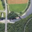
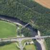
Craigellachie, New Bridge


Road Bridge (19th Century)
Site Name Craigellachie, New Bridge
Classification Road Bridge (19th Century)
Alternative Name(s) Craigellachie Pot; Craigellachie Bridge; River Spey
Canmore ID 90962
Site Number NJ24NE 26
NGR NJ 28659 45176
Datum OSGB36 - NGR
Permalink http://canmore.org.uk/site/90962


- Council Moray
- Parish Aberlour
- Former Region Grampian
- Former District Moray
- Former County Banffshire
NJ24NE 26 28659 45176
Location formerly cited as NJ 2865 4518.
For predecessor Telford Bridge (adjacent to W), see NJ24NE 15.
Craigellachie Bridge [NAT]
OS 1:10,000 map, 1976.
Craigellachie Bridge [NAT]
OS (GIS) AIB, April 2006.
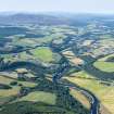
This bridge carries the present line of the A95 public road over the River Spey, which here forms the boundary between the parishes of Aberlour (to the S) and Rothes (to the N).
The location assigned to this record defines the midpoint of the main (Southern) span. The available map evidence indicates that the structure extends from NJ c. 28648 45147 to NJ c. 28698 45293.
Information from RCAHMS (RJCM), 7 April 2006.

