
Scalan, Pond


Dam (Period Unassigned), Pond (Period Unassigned), Sluice (Period Unassigned)
Site Name Scalan, Pond
Classification Dam (Period Unassigned), Pond (Period Unassigned), Sluice (Period Unassigned)
Alternative Name(s) Braes Of Glenlivet
Canmore ID 117669
Site Number NJ21NW 21.02
NGR NJ 2467 1935
Datum OSGB36 - NGR
Permalink http://canmore.org.uk/site/117669

- Council Moray
- Parish Inveravon
- Former Region Grampian
- Former District Moray
- Former County Banffshire
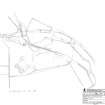
The 1972 1:10000 map of the area around Scalan shows a system of water channels and associated features which once served the water-powered mill at the south steading at Scalan.
A branch of the Slochd Burn was dammed to form a mill pond, from which the flow of water was regulated through a sluice gate. When opened, water was directed down a lade or channel to drive the mill wheel.
Text prepared by RCAHMS as part of the Accessing Scotland's Past project

