
Pricing Change
New pricing for orders of material from this site will come into place shortly. Charges for supply of digital images, digitisation on demand, prints and licensing will be altered.
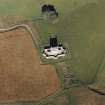
Corgarff Castle, Building And Pond


Building (Period Unassigned), Pond (Period Unassigned)
Site Name Corgarff Castle, Building And Pond
Classification Building (Period Unassigned), Pond (Period Unassigned)
Canmore ID 137822
Site Number NJ20NE 1.01
NGR NJ 2544 0862
Datum OSGB36 - NGR
Permalink http://canmore.org.uk/site/137822


- Council Aberdeenshire
- Parish Strathdon
- Former Region Grampian
- Former District Gordon
- Former County Aberdeenshire
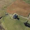
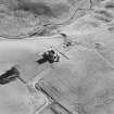
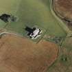
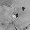
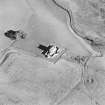
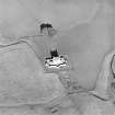
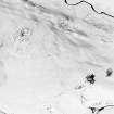
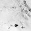
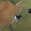
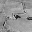
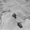
There are no visible remains of a long rectangular pond that is depicted to the south of Corgarff Castle on the first edition of the OS six-inch map. The pond was fed by the Allt Bad Mhic Griogair, but was out of use by the turn of the century and is not shown on the second edition of the map. By this date, a roofed rectangular building is shown at the south end of the former pond, and the stone wall-footings of this can still be seen. A complex of sheep pens and a dip now occupy the site.
Text prepared by RCAHMS as part of the Accessing Scotland's Past project
NJ20NE 1.01 2544 0862
(Location cited as NJ 2545 0865). There are no visible remains of the long building that lay immediately to the S of Corgarff Castle and is depicted as roofed on the 1st edition of the OS 6-inch map (Aberdeenshire 1869, sheet lxviii). It probably stood on a grassy terrace which now bears a complex of sheep pens and a dip. Downslope from the terrace at the S end of the E side, there are the remains of a building that may have originally joined onto the long building. It measures about 10.6m from NNE to SSW by 5.2m over low mortared stone wall-footings 0.6m thick.
Visited by RCAHMS (JRS), 22 May 1997.
(Location amended to NJ 2544 0862).
(Undated) information in NMRS.
On further examination of the 1st edition of the OS 6-inch map (Aberdeenshire 1869, sheet lxviii), no buildings were depicted at the location cited. The depiction of a pond, may have led to the misinterpretation of this feature as a long building.
By the 2nd edition of the OS 6-inch map (Aberdeenshire 1902, sheet lxviii), the pond is no longer shown, but a building, probably that identified during the RCAHMS field visit situated to the E of the S end of the former pond, is depicted as roofed.
Information from RCAHMS (AKK) 22 April 1999.

