
Following the launch of trove.scot in February 2025 we are now planning the retiral of some of our webservices. Canmore will be switched off on 24th June 2025. Information about the closure can be found on the HES website: Retiral of HES web services | Historic Environment Scotland
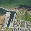
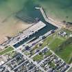
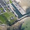
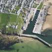
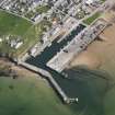
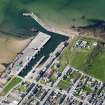
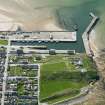
Burghead, Bonnieview, Coastguard Station, Lookout Point And Storm Signal


Coastguard Station (19th Century), Pillbox (Second World War)
Site Name Burghead, Bonnieview, Coastguard Station, Lookout Point And Storm Signal
Classification Coastguard Station (19th Century), Pillbox (Second World War)
Alternative Name(s) Burghead Harbour, Storm Signal; Burghead, Storm Signal To North Of Harbour
Canmore ID 159113
Site Number NJ16NW 88.01
NGR NJ 10839 69178
Datum OSGB36 - NGR
Permalink http://canmore.org.uk/site/159113


- Council Moray
- Parish Duffus
- Former Region Grampian
- Former District Moray
- Former County Morayshire
NJ16NW 88.01 10839 69178
Coastguard Lookout [NAT]
OS 1:2500 map, 1967.
NJ 109 691 At Burghead Fort, excavations were undertaken between February and April 2002, and a watching brief was conducted during further construction works between April and July 2002 in advance of the proposed construction of an interpretation centre within the 19th-century coastguard lookout. This lookout is set at the N end of the fort on top of the rampart which separates the upper and lower wards. The lookout is specifically excluded from the Scheduling of the fort.
The excavation of deposits within the lookout demonstrated that it had been built on top of extant rampart core material with little resultant disturbance of the rampart beneath. A section excavated through the rampart at this point demonstrated that it was stone-built of dump construction with no evidence for timber-lacing. The body of the rampart consisted of a mixture of large waterworn stones and apparently quarried sandstone with pockets of large beach pebbles, within a sand matrix. Fragments of sandstone were present throughout. There appeared to be little organised structure to the rampart's construction, although some variation could be seen within the rampart core; for example, pockets of beach pebbles were locally prevalent. Larger stones were visible towards the base of the section, with more voids present, perhaps indicating that a layer of basal stones had been laid on the ground surface initially to mark out the line of the rampart and/or provide a firm foundation for the rampart. The section of rampart excavated measured 8m wide (max.) and 3.00-3.25m high (max.). The excavation within the lookout did not extend through the inner or outer faces of the rampart due to the constraints imposed by working within the confines of that building. No artefacts were recovered.
Sealed beneath the rampart was a sequence of well-preserved organic deposits. Further excavation of these deposits showed that there were two old land surfaces separated by windblown sand, with relict dune sands beneath. These land surfaces were organic-rich and contained charred plant remains. No features were noted within these deposits.
Data Structure Reports deposited in the NMRS.
Sponsor: Moray Council for Burghead Headland Trust.
M Johnson 2002.
Watching Brief (May 2012 - August 2012)
NJ 10839 69178 A watching brief was undertaken May – August 2012 at Burghead Pictish Fort and Visitor Centre (former coastguard station) during work associated with a toilet extension and associated services. Work to the E edge of the coastguard station revealed part of the retaining wall of the rampart and a small section of wall of unknown function. Monitoring of services revealed little or no archaeological deposits. The area had been heavily disturbed during the building of the coastguard housing and lay in an area previously excavated by Alan Small in 1966.
Archive and report: RCAHMS (intended)
Funder: Burghead Headland Trust
Stuart Farrell,
2012
Note (31 August 2015)
Located to the W of the lookout is a square concrete plinth. This is the remains of a pillbox, visible on a 1952 Aero Pictorial Ltd image of the harbour and headland.
Information from RCAHMS (AKK) 31 August 2015.

