
Pricing Change
New pricing for orders of material from this site will come into place shortly. Charges for supply of digital images, digitisation on demand, prints and licensing will be altered.
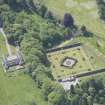
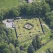
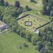
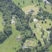
Ballindalloch Castle, Walled Garden


Walled Garden (19th Century) (1830)
Site Name Ballindalloch Castle, Walled Garden
Classification Walled Garden (19th Century) (1830)
Alternative Name(s) Ballindalloch Castle Estate; Ballindalloch Castle Policies
Canmore ID 193728
Site Number NJ13NE 4.08
NGR NJ 17787 36938
Datum OSGB36 - NGR
Permalink http://canmore.org.uk/site/193728


- Council Moray
- Parish Inveravon
- Former Region Grampian
- Former District Moray
- Former County Banffshire
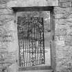
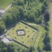
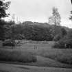
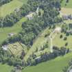
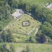
A walled garden lies to the north of Ballindalloch Castle, reached by a short path leading through an area of woodland. It was constructed about 1830, after a flood in 1829 destroyed its predecessor.
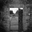
The garden is roughly square in shape, and is bounded by rubble walls. There were entrances at the north and south, which contained ornamental iron gates. A map published in 1890 shows that the garden was divided into four parts by two paths, and paths also run alongside the wall.
A small bothy is built against the exterior of the north wall. Constructed of rubble, with a slate roof, it would have provided a place to rest on walks around the grounds and gardens. In 1996, the interior of the garden was redesigned, with colourful plants and curving paths, to celebrate the 450th anniversary of the castle.
Text prepared by RCAHMS as part of the Accessing Scotland's Past project
NJ13NE 4.08 17787 36938

