
Pricing Change
New pricing for orders of material from this site will come into place shortly. Charges for supply of digital images, digitisation on demand, prints and licensing will be altered.
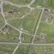
Tain Airfield, Royal Air Force Station, Technical Site


Air Raid Shelter(S) (20th Century), Aircraft Hangar(S) (20th Century), Building(S) (20th Century)
Site Name Tain Airfield, Royal Air Force Station, Technical Site
Classification Air Raid Shelter(S) (20th Century), Aircraft Hangar(S) (20th Century), Building(S) (20th Century)
Canmore ID 109495
Site Number NH88SW 14.04
NGR NH 83121 81437
NGR Description Centred NH 83121 81437
Datum OSGB36 - NGR
Permalink http://canmore.org.uk/site/109495


- Council Highland
- Parish Tain
- Former Region Highland
- Former District Ross And Cromarty
- Former County Ross And Cromarty
NH88SW 14.04 Centred 83121 81437
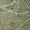
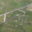
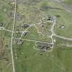
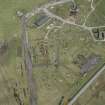
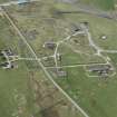
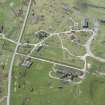
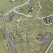
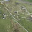
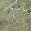
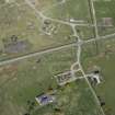
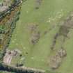
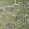
Between the public road from Tain to Portmahomack and the airfield control tower (NH88SW 14.05) are the remains of many brick and concrete buildings, hangar bases, hard-standings, air-raid shelters and offices. This area is annotated on the PRO plan of the airfeld (PRO 77/1/1412) as the technical site and incorporated many of the non accommodation buildings that were required by a working airfield. Within this part of the airfield would be HQ, photographic offices, garages, main store, parachute stores, decontamination centres etc. The most impressive still upstanding are the main stores, surviving as an 'H' shaped building in the centre of the group where the loading bay and large garage or fabric store, now used by the farmer to store cattle feed, survive. Other notable buidings still roofed are the torpedo workshop, a long narrow structure on the W side of the area and the foundations of a very large building which was the main motor transport shed and yard. The station headquarters building immediately N of the main entrance is also extant and roofed along with several workshops. Most of the other buildings have been reduced to either rubble or are unroofed and collapsing.
Visited by RCAHMS (DE) May 1997
Note (2 May 2022)
The Pillbox Study Group report a Stanton type air raid shelter is visible on Google aerial imagery dated 2010.
Information from Pillbox Study Group 2 May 2022

