
Shandwick, Chapel And Graveyard


Burial Ground (Medieval), Chapel (Medieval)
Site Name Shandwick, Chapel And Graveyard
Classification Burial Ground (Medieval), Chapel (Medieval)
Alternative Name(s) Old Shandwich
Canmore ID 15275
Site Number NH87SE 1
NGR NH 8582 7453
Datum OSGB36 - NGR
Permalink http://canmore.org.uk/site/15275


- Council Highland
- Parish Nigg (Ross And Cromarty)
- Former Region Highland
- Former District Ross And Cromarty
- Former County Ross And Cromarty
NH87SE 1 8582 7453
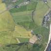
(NH 8582 7453) Chapel (NR) (Site of)
OS 6" map, Ross-shire, 2nd ed., (1907).
At Shandwick there was a chapel and graveyard, and the walls of the former were "nearly entire" towards the end of the 18th century (OPS 1855). The chapel is said to be coeval with the adjacent castle (ie. 15th century) (NH87SE 2) (Ordnance Survey Name Book [ONB] 1872).
During the 1939-45 war, stone was quarried from this site to build the RNAS airfield at Loans of Rarichie. Not much was cut away on the E of the site, but enough to expose graves and bones, the latter being thrown away.
Dressed stones and the remains of a wall were found, now flush with the ground and about 20' long. The length is parallel with the face of headstone 'A'.
Orig Paroch Scot 1855; Name Book 1872; Information from J Howdle to OS 29 August 1961; Information from H Ross, general merchant, Shandwick, H Ross, farm worker, Old Shandwick Farm, A Vass, 4 Park of Balintore and Christie, shepherd, Cullisse to OS.
No trace of the chapel. Little remains of the graveyard which has been partially destroyed by quarrying and more recently by a silage pit when several skeletons were disturbed. A skull was recently exposed beside headstone 'A' and was immediately reburied (information from H Ross, Old Shandwick Farm). The footings of the wall, 0.6m thick, noted by Howdle can be traced for about 15.0m running N-S. It cannot be established if it is part of the graveyard wall or not.
Visited by OS (I S S), 29 August 1972.
Castle and Chapel. The base of 1 wall remains roughly E-W. 2 upright slabs, possible grave stones remain, very close to edge of quarry (NH87SW 52). Slight mound and lots of stones lying about. Wall 20m by 0.7m, 1 course high. Uncertain what the remains relate to. Too thin for a castle wall.
CFA/MORA Coastal Assessment Survey 1998.
Field Visit (October 1977)
Old Shandwick, Chapel NH 858 745 NH87SE 1
Only two dressed stones and a length of walling survive of this chapel, which stood within
a burial-ground until the end of the 18th century.
RCAHMS 1979, visited October 1977
(Stat Acct, xiii, 1794, 19; OPS 1851-5, ii, 455)
Field Visit (2013 - 2014)
Grass covered and under threat from erosion. Upright slabs very close to quarry edge one less than 1/2 meter.
Visited by Scotland's Coastal Heritage at Risk (SCHARP) 2013

