
Dounie


Standing Stone (Prehistoric)(Possible)
Site Name Dounie
Classification Standing Stone (Prehistoric)(Possible)
Canmore ID 13848
Site Number NH68NE 46
NGR NH 6944 8672
Datum OSGB36 - NGR
Permalink http://canmore.org.uk/site/13848


- Council Highland
- Parish Edderton
- Former Region Highland
- Former District Ross And Cromarty
- Former County Ross And Cromarty
NH68NE 46 6944 8672
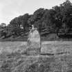
Situated in a field some 300m NE of Dounie is a thin, pointed slab, 2.1m high, 1.0m long and 0.2m thick; it is published as Standing Stone in non-antiquity type on OS 6" map, Ross-shire, 2nd ed., (1907). It is unmarked and no information about it could be obtained locally.
Visited by OS (WDJ) 17 June 1963.
Field Visit (9 September 1943)
Standing Stone, Dounie
This stone stands in an arable field, just over 50 ft above sea level, about 350 yds NE of Dounie. It is 6 ft. 7 in. high, 3 ft.6 in. wide and 7 ½ in. thick, its major axis running on a bearing of 160 degrees (true). It leans slightly towards the east.
Visited by RCAHMS (AG, VGC) 9 September 1943.
Field Visit (September 1978)
Dounie NH 694 867 NH68NE
What may have been a prehistoric standing stone was removed about 1970 from a field 300m NE of Dounie. It measured 2.1 m high, 1 m broad and 0.2m thick; a sandstone slab lying on a near-by clearance heap may be the stone.
RCAHMS 1979, visited September 1978
(OS Record Card NH 68 NE (M) 1)

