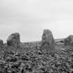
Torbreck
Stone Circle (Neolithic) - (Bronze Age)
Site Name Torbreck
Classification Stone Circle (Neolithic) - (Bronze Age)
Canmore ID 13542
Site Number NH64SW 1
NGR NH 64374 40390
Datum OSGB36 - NGR
Permalink http://canmore.org.uk/site/13542
- Council Highland
- Parish Inverness And Bona
- Former Region Highland
- Former District Inverness
- Former County Inverness-shire
NH64SW 1 6437 4037.
(NH 6437 4037) Stone Circle (OE)
OS 6"map, Inverness-shire, 2nd ed., (1906)
A complete circle consisting of nine stones, at a short distance from which are two other stones, supposed to be the remains of an outer Circle.
Name Book 1868.
The circle at Torbreck seems to have been interfered with in improving the field in which it stands. At one time three concentric circles, with a passage connecting the outer and inner rings were visible.
J Fraser 1884.
Fraser's plan shows a circular setting of nine evenly spaced upright stones with an external diameter of 17 ft. It does not appear to be part of a chambered cairn; Fraser suggested the stones had been moved but it seems more likely that it is a stone circle.
A S Henshall 1963, visited 11 April 1957.
Stone Circle:- A stone circle of 9 almost evenly spaced monoliths (maximum height 1.2m) with an overall diameter of 7.8m. A quantity of small stones lies upon the site, but these appear to be the result of field clearance. The site lies within a cultivated field. There are no traces of an outer circle.
Visited by OS (J L D) 22 March 1962.
Field Visit (19 August 1943)
This monuments stands about 500yds south west of Torbreck, its site being a shelf of arable land not quite 200ft above sea level and overlooking the River Ness, which flows along the bottom of the valley to the NW. It consists of eight upright stones and one fallen one, disposed, as shown over-leaf, on the periphery of a figure approximating a circle 20ft in diameter. Whether it is to be regarded as the remains of a chambered cairn of Clava type is doubtful; especially as the stones are graded in height from a tall pair on the SSW (B and C) through others of intermediate height (A and D) to the lowest (E, G, H and J) on the north sector, and this is a feature of an outer ring, for which the diameter of this circle is too small, rather than a peristalith or a chamber. Stone F cannot be placed in the height-series with certainty as it has fallen outwards and is partly covered with turf. The dimensions of all the stones are as follows in the order height, breadth, thickness: C, 6ft by 3ft 9in by 2ft 9in; B, 5ft 3in by 3ft 6in by 2ft 4in; D, 4ft 6in by 3ft 8in by 2ft 3in; A, 4ft 3in by 3ft 3in by 2ft; F, originally perhaps, over 4ft by 3ft by an unknown thickness; J, 3ft 11in by 2ft 6in by 1ft 9in; E, 3ft 8in by 2ft 8in by 1ft 10in; G 3ft 8in by 4ft 6in by 2ft 11in; H, 3ft 8in by 2ft 6in by 1ft 10in. A hollow about 6ft in diameter by 1ft deep has been dug slightly to the NW of the apparent centre of the monument.
Visited by RCAHMS (A Graham) 19 August 1943.
Field Visit (June 1978)
Torbreck NH 643 403 NH64SW 1
What is probably a stone circle stands 700m SW of Torbreck farmhouse; it measures about 8m in diameter and comprises nine stones graded in height from 0.95m on the NE to 1.55m on the SW. In 1868 the OS noted two stones of what may have been an outer circle. In 1943 the RCAMS noted that the stone on the NW had fallen; this stone has since been re-erected.
RCAHMS 1979, visited June 1978
(MS. notes in NMRS, RCAMS Emergency Surveys; Henshall 1963-72, i, 385)


