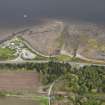
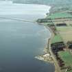
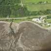
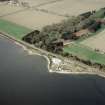
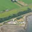
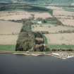
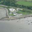
Accessibility

Font Size

100% 150% 200%

Background Colour

Default Contrast
Close Reset

Foulis Point

Fish Trap (Period Unassigned)

Site Name Foulis Point

Classification Fish Trap (Period Unassigned)

Canmore ID 294792

Site Number NH56SE 56

NGR NH 5992 6335

Datum OSGB36 - NGR

Permalink http://canmore.org.uk/site/294792

Ordnance Survey licence number AC0000807262. All rights reserved.
Canmore Disclaimer. © Bluesky International Limited 2025. Public Sector Viewing Terms

Toggle Aerial | View on large map

Digital Images

Oblique aerial view of the fish traps at Foulis Ferry, looking SE.
Oblique aerial view of the fish traps at Foulis Ferry, looking SE.Aerial view of Foulis Point and Cromarty Bridge, Cromarty Firth, looking SW.Oblique aerial view of the fish traps, looking NW.Aerial view of Foulis Point, Evanton, Easter Ross, looking W.General aerial view of Foulis Ferry on the Cromarty Firth, looking N.Aerial view of Foulis, Evanton, Easter Ross, looking NW.Oblique aerial view of Foulis Ferry Granary, N shore of Cromarty Firth, looking W.

Collections

Administrative Areas

  • Council Highland
  • Parish Kiltearn
  • Former Region Highland
  • Former District Ross And Cromarty
  • Former County Ross And Cromarty

Archaeology Notes

NH56SE 56 5992 6335

Fish trap - poor condition.

CFA/MORA Coastal Assessment Survey 1998.

References

MyCanmore Image Contributions


Contribute an Image

MyCanmore Text Contributions