
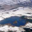
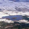
Loch Ussie


Hut Circle (Prehistoric)
Site Name Loch Ussie
Classification Hut Circle (Prehistoric)
Canmore ID 12462
Site Number NH45NE 64
NGR NH 4991 5661
Datum OSGB36 - NGR
Permalink http://canmore.org.uk/site/12462


- Council Highland
- Parish Fodderty
- Former Region Highland
- Former District Ross And Cromarty
- Former County Ross And Cromarty
NH45NE 64 4991 5661
Situated on a low rise on the W side of Loch Ussie there are the remains of a hut-circle which measures 8m in diameter within a low, turf-covered bank 2m in thickness and about 0.2m in height. The wall has clearly been robbed of its original inner and outer facing-stones and there is a narrow entrance on the SE. The hut-circle lies some 18.5m WNW of a burnt mound (NH45NE 68).
Visited by RCAMS (JRS) 27 February 1989.

