
Pricing Change
New pricing for orders of material from this site will come into place shortly. Charges for supply of digital images, digitisation on demand, prints and licensing will be altered.
Upcoming Maintenance
Please be advised that this website will undergo scheduled maintenance on the following dates:
Thursday, 9 January: 11:00 AM - 3:00 PM
Thursday, 23 January: 11:00 AM - 3:00 PM
Thursday, 30 January: 11:00 AM - 3:00 PM
During these times, some functionality such as image purchasing may be temporarily unavailable. We apologise for any inconvenience this may cause.
Inverlael


Field System (Period Unassigned), Head Dyke (Post Medieval), Township (Period Unassigned), Mount (Copper)
Site Name Inverlael
Classification Field System (Period Unassigned), Head Dyke (Post Medieval), Township (Period Unassigned), Mount (Copper)
Canmore ID 12120
Site Number NH18NE 9
NGR NH 1843 8583
NGR Description Centred at NH 1843 8583
Datum OSGB36 - NGR
Permalink http://canmore.org.uk/site/12120


- Council Highland
- Parish Lochbroom
- Former Region Highland
- Former District Ross And Cromarty
- Former County Ross And Cromarty
NH18NE 9 1843 8583 (Centred).
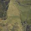
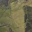
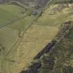
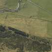
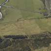
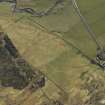
In the area centred at NH 185 857 there is a deserted township known as Inverlael, (Visible on air photographs RAF CPE/Scot/321:3301-2) comprising the remains of about 63 rectangular dry-stone buildings, varying in height from grass-covered footings, 0.2m high to 1.3m high, several field walls and enclosures, maximum height 1.3m, and a corn-drying kiln, 0.8m high. The township lies mainly in pastureland, although the eastern area is densely afforested.
Surveyed at 1/2500.
Visited by OS (N K B) 16 October 1964
'No visible remains of former village' (at NH 186 858). However, 'building and house foundations' at NH 186 856; 'kiln' at NH 186 855; 'foundation' at NH 187 854; and 'longhouse and bothy' at NH 188 854, all within the boundaries of Inverlael, are listed, but no details given.
D W Ross 1990.
A township, comprising thirty unroofed structures, of which twelve are buildings, three enclosures, a field-system and a head-dyke is depicted on the 1st edition of the OS 6-inch map (Ross-shire & Cromartyshire 1881, sheet xxxv). Fifty-seven unroofed structures, of which at least twelve are buildings, and a field-system are shown on the current edition of the OS 1:10560 map (1969).
Information from RCAHMS (AKK) 17 February 1996.
NH 185 858 Copper-alloy hinged sporran fitting of 18th-century type with ring-dot decoration. Metal detector find associated with MOLRS site.
R G Hanley and J Whitteridge 1996
Publication Account (2009)
The website text produced for Lael Forest Shielings webpages on the Forest Heritage Scotland website (www.forestheritagescotland.com).
Introduction: On the edge of lael Forest
The remains of the township of Inverlael stand on the edge of Lael Forest. Here, and within the forest, you can discover evidence of daily life over two hundred years ago.
Historical records date Inverlael to the 13th century, but it may well be older, though the remains you can see today are probably 18th century.
Until the establishment of the fishing town of Ullapool, Inverlael was said to be the largest settlement north of Dingwall. It remained inhabited until 1888.
Today, at least twelve ruined buildings survive, along with associated structures including a corn drying kiln. Aerial photographs show us the outlines of fields where the inhabitants grew their crops. Within the forest, you can also discover traces of livestock enclosures and shieling huts.
In the 18th and early 19th century, the land where Lael Forest now stands, was part of the estates belonging to George MacKenzie of Coul.
Mackenzie, like many other landlords, believed in the need for farming improvements in the Highlands, and he wrote many papers about the subject. You can find out more about George Mackenzie and his ideas about farming at Rogie.
In 1820, Mackenzie began evicting families from Inverlael to make way for sheep farming. Many of the evicted tenants emigrated to America; others moved to Ullapool to find work.
People Story: In the summer....
Cattle were an important part of the daily life for the people of Inverlael township.
In the summer months, the women and the young people left the village to go to the nearby shielings. Shielings were areas of good grass land for cattle to graze, often in remote or mountainous areas.
Within Lael Forest, there are the remains of temporary structures, called shieling huts. The young women from the township would stay at these huts with the cattle during the summer. They made butter and cheese form the cow's milk and prepared for the winter ahead.
Nearby the huts, you can discover a stream called "Allt na-h-ighine", which translated means "the stream of the young women". Perhaps it was their source of fresh water during the summer months.
The men would stay at the township, prepare for harvest and undertake any necessary renovations to the buildings; again in preparation for the winter.
You can discover more about their summer activities at [b][url=http://www.forestheritagescotland.com/explore?Sites=56]Cochno Shielings[/url][/b].
In the autumn, the farmers sold any extra cattle to cattle dealers or drovers, who took large herds south to markets in the lowlands.
An old drove road passes close to Inverlael, continuing on to Dingwall. You can discover more about drovers at the cattle market site on Mull, Cnoc nam Dubh Leitre.
Evidence Story: Using theStatistical Accounts of Scotland
By the late 19th century, Inverlael was abandoned. The Statistical Account of Scotland tells us that people were leaving this area as early as the 18th century due to the changes in farming.
The Statistical Account of Scotland is a valuable source of information. From 1791 to 1799, a written record was made of over 930 parishes, usually undertaken by the minister of the local parish church. The New (1834-1845) and Third (1951-1992) Statistical Accounts followed. A comparison of all three provides a picture of the agricultural changes and their affect on society since the 18th century.
In 1798, Reverend Macrae wrote that the population of Lochbroom parish was declining. For this, he blamed the landowner’s treatment of their tenants and “the engrossing of farms for sheep walks”.
“The mode of farming being introduced lately into some parts of the parish and proved the occasion of reducing to hardship several honest families who lived tolerable happy on the fruits of their industry and frugality”.
Statistical Account 1798
As a result, many families left the area, either emigrating to America or moving to find new work elsewhere.
Dramatically he described land as empty
“...where formerly hundreds of people could be seen, no human faces are now met with, except a shepherd attended by his dog”.
Statistical Account 1798
It is important to remember that these accounts were personal and could be biased. While the population diminished, townships such as Inverlael continued for a further one hundred years and more.

