
Scheduled Maintenance
Please be advised that this website will undergo scheduled maintenance on the following dates: •
Tuesday 3rd December 11:00-15:00
During these times, some services may be temporarily unavailable. We apologise for any inconvenience this may cause.
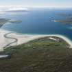
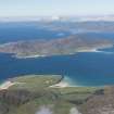
Harris, Luskentyre


Burial Ground (Period Unassigned), Township (Period Unassigned), Carved Object (Stone)
Site Name Harris, Luskentyre
Classification Burial Ground (Period Unassigned), Township (Period Unassigned), Carved Object (Stone)
Alternative Name(s) Losgaintir
Canmore ID 260936
Site Number NG09NE 14
NGR NG 0673 9936
NGR Description Centred on NG 0673 9936
Datum OSGB36 - NGR
Permalink http://canmore.org.uk/site/260936


- Council Western Isles
- Parish Harris
- Former Region Western Isles Islands Area
- Former District Western Isles
- Former County Inverness-shire
NG09NE 14 centred on 0673 9936
NG 06910 99512 Amid dense undergrowth and on top of a substantial sand mound which contains the old part of Losgaintir cemetery, a gneiss slab 13mm high. The stone appears to be an attempt to illustrate a seal's outline with other features crudely shaped to this effect, the piercing being the eye of the seal.
James Crawford, 2006.
Casual Observation (2006)
NG 06910 99512 Amid dense undergrowth and on top of a substantial sand mound which contains the old part of Losgaintir cemetery, a gneiss slab 13mm high. The stone appears to be an attempt to illustrate a seal's outline with other features crudely shaped to this effect, the piercing being the eye of the seal.
J Crawford 2006

