
Scheduled Maintenance
Please be advised that this website will undergo scheduled maintenance on the following dates: •
Tuesday 3rd December 11:00-15:00
During these times, some services may be temporarily unavailable. We apologise for any inconvenience this may cause.
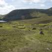
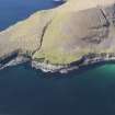
St Kilda, Hirta, General


General View (Period Unassigned)
Site Name St Kilda, Hirta, General
Classification General View (Period Unassigned)
Alternative Name(s) Hiort, Hirte
Canmore ID 294832
Site Number NF19NW 60
NGR NF 10073 99342
NGR Description Centred NF 10073 99342
Datum OSGB36 - NGR
Permalink http://canmore.org.uk/site/294832


First 100 images shown. See the Collections panel (below) for a link to all digital images.
- Council Western Isles
- Parish Harris
- Former Region Western Isles Islands Area
- Former District Western Isles
- Former County Inverness-shire
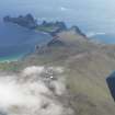
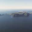
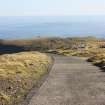
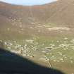
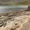
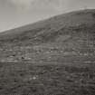
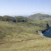
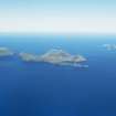
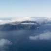
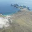
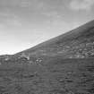
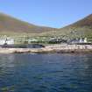
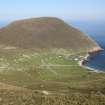
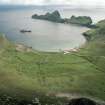
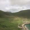
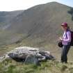
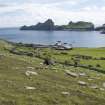
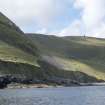
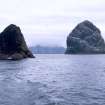
ST. KILDA The St. Kilda archipelago - four islands with attendant sea stacs - looms up on the Atlantic horizon 41 miles west of North Uist. Their jagged, volcanic forms and towering cliffs create a backdrop of breathtaking drama for a landscape of exceptional cultural and ecological significance. St. Kilda is the remotest of the outlying Hebridean islands, but it is also the best documented. It has been described in literature, poetry and visitors' accounts for many centuries, and is the subject of considerable research and a unique photographic archive. The islanders lived off fulmars, gannets and puffins, harvesting the seabirds for their oil, flesh, eggs and feathers, and paying the proceeds of their remarkable fowling skills to the Macleod landlords in lieu of rent. Everything was jointly owned and the community governed itself through a 'parliament', which met daily to decide what work was to be done. Archaeological evidence suggests that St. Kilda has been almost continuously occupied for 4,000 years. Early Bronze Age burial mounds, an Iron Age souterrain and house remains, Viking finds, remnants of medieval structures, cultivation and three early chapel sites, have all been recorded. The population reached nearly 200 in the late 17th century, but it was vulnerable to disease brought by visiting ships, such as the smallpox epidemic of 1724 , and after 1850 numbers never exceeded 70. Early on, St. Kilda became a popular curiosity for tourists - the first boatload arrived in 1834 - and the islanders began to rely on outside commodities and communications, and on money paid to them for souvenirs. Increasingly, their independence was threatened and the livelihood of this isolated community became unsustainable; further damage was done to ancient traditions by the puritanical regime imposed by incoming clergymen. The story of the evacuation of St. Kilda in 1930, when the last 36 remaining inhabitants finally departed at their own request, is well known. A year later, the island group was bought by the future 5th Marquess of Bute, who bequeathed it to the National Trust for Scotland in 1957, the year the radar tracking station was established. The archipelago is now, among many other designations, a World Heritage Site and a National Nature Reserve. Indeed, it is probably true to say that Britain's remotest outpost is more strongly protected than any other part of the British Isles.
Taken from "Western Seaboard: An Illustrated Architectural Guide", by Mary Miers, 2008. Published by the Rutland Press http://www.rias.org.uk

NF19NW 60 centred 10073 99342
Incorporates information from Cancelled site No. NF09NE 11
N.B. Soay General is NA00SE 8 and Boreray General is NA10NE 2
St Kilda Artefacts and Manuports Project (SKAMP). Three weeks' work in July 2004 has brought the fieldwork stage of the project to a conclusion, and the way is now open for the preparation of a report for an academic journal on the character, distribution and quantitative aspects of the numerous artefacts, unmodified beach cobbles and fire-cracked stones in the standing structures at Village Bay. The close parallels between Hirta's late prehistoric lithic material and that of the Northern Isles, already apparent in the case of the dolerite hoe-blades (Fleming and Edmonds 1999) have been confirmed in relation to a wider range of artefacts (e.g. pounder/grinders and Skaill knives), and in this respect the advice and help of Ann Clarke, who was present for the first week of the 2004, has been invaluable. Several fragments of rotary querns were discovered this year (their likely date is under investigation) and also half a trough quern. A small but reasonably representative 'assemblage' of lithic material from the exclosure walls around cleits 152/153 was subject to detailed study. A small number of finds from the walls of the 'modern' fields in the St Brianan's chapel area helped to confirm suspicions that there is an ancient field system here, re-used in relatively recent times.
Andrew Fleming 13 October 2004.
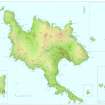
The islands forming the St Kilda archipeligo include Hirta, Soay, Dun and Boreray, the latter with its attendant stacks, Stac Lee and Stac an Armin. Together they fall over eight 1:10,000 mapsheets. All General Views are catalogued under this number, NF19NW 60.
Information from RCAHMS (ARG) 13 June 2008
This site carries information on Hirta and Dun only.
NF19NW 60 centred 10073 99342
EXTERNAL REFERENCE:
National Library of Scotland: Map Collection.
Robert Stevenson. MS 448.82 ( 5862 No 10 ) Map of St Kilda giving some idea of the pre 1835 village.
See also: 'St Kilda' by Bill Lawson - unpublished typescript (not available to the public without written permission of Mr B Lawson, The Old School House, Northton, Harris, Outer Hebrides'. Stored in Limited Access file.)
See also: ' St Kilda evacuated : islanders leave homes of their ancestors', from 'The Glasgow Herald', 30 August, 1930. ( Photographs of the island and the people before and during departure).
D5/IN (p). Acc. No. 14369(P).
Non-Guardianship Sites Plan Collection, DC28525- DC28540, 1850 - 1860, 1957, 1963 & 1983.
Publication Account (1985)
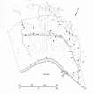
The St Kilda archipelago consists of the four islands of Hirta, Dun, Soay and Boreray, with associated stacks and islets; it belongs to the National Trust for Scotland and is leased to the Nature Conservancy Council as a National Nature Reserve. A small portion of Hirta is sub-let to the Ministry of Defence.
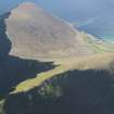
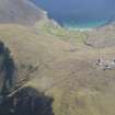
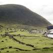
The date of the earliest settlement of the islands is not known, but it is clear from documentary evidence that there was a community living there by medieval times. There are very few structures which can definitely be attributed to any period earlier than the 19th century, and it is the village complex laid out in the 1830s which immediately impresses the visitor upon entering Village Bay. The resident minister at that time, offended by the squalid habitations of his parishioners, persuaded them to build new homes. The arable land, which had until then been divided into numerous strips that were re-allocated every three years, was pennanently apportioned in a pattern of strips radiating from the curve of the shore; the new houses were built along a street curving behind the shore and the whole was surrounded by a head-dyke. The small houses were of the blackhouse type, with the family living at one end and the cattle in the byre at the other end. In the 1860s these houses were given over entirely to cattle and storage, the families moving into new mortared buildings, which were more spacious, although in some ways less practical, for they faced the bay and therefore the worst of the weather; they also had thin walls and zinc roofs, which caused severe condensation, but after the roofs blew off tarred felt was found to be more satisfactory.
Near the rocks which were used as a landing place is a two-storey building used to store the commodities accumulated to pay the rent: tweed, oil, fish, and feathers. A little further along the shore is the manse and church, built in 1828 to plans by Robert Stevenson; a schoolroom was built onto the church in 1900. Another two-storey building was the house where the factor stayed during his annual visit to collect the rent, and in the late 19th century this house was also used by teachers and various visitors, and in this century by the district nurse. Just behind the village street is an oval walled graveyard. There is now no trace of Christ's Church, which stood here in medieval times, although a stone with a cross cut into it, presumably of medieval date, is built into the front wall of Cottage 16 at the west end of the street, and another cross fonns part of the ceiling of a cleit behind the village.
Not far from the burial ground is a short underground passage or souterrain, similar to some found in the Western Isles and on the mainland. Sherds of iron-age pottery have been found in this structure.
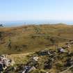
Behind the village and outside the head-dyke are several beehive-shaped structures. There is evidence that smaller cells were built adjacent to these, with a connecting passage. These buildings may include elements of the houses in use before 1830.
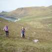
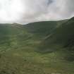
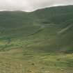
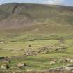
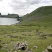
Scattered within the village and over large areas of the surrounding hills are many drystone buildings called cleits. These have parallel walls enclosing a narrow space, rounded ends, and a door at the end facing uphill or occasionally on one side. The rooflintels are covered with stones capped with earth and turf. The thick roof prevents the rain penetrating, but the air circulated between the walls, drying anything inside. These buildings were used for storage; in the village area they contained a variety of things-birds, fish, hay and turf; on the hills many still contain pieces of turf cut for fuel. Throughout their recorded history, the islanders depended to a great extent for their food on the sea birds which thronged the cliffs and slopes; the large populations of puffins, gannets and fulmars were harvested on a scale unknown elsewhere in Britain.
On the north side of the island in Gleann Mor another type of building is found-a small walled court with two or three small adjoining cells; low walls fonn a funnel-like entrance to the court There are about twenty of these structures in the floor of the Glen. Latterly they were used as shielings, although it is possible that they were originally built for another purpose. Also in Gleann Mor is the Amazon's House, a complex beehive construction, now very dilapidated. It is referred to by Martin Martin, who visited the islands in 1697, as the House of the Female Warrior-reputed to have been a princess from Hams. There are more cleits and bothies on Boreray, Soay and Stac an Armin, but it is difficult to land on these islands, and, while there was seasonal occupation on Boreray, it is very doubtful if they were ever pennanently inhabited.
The maximum recorded population was 180 at the end of the 17th century, when the islands supported a thriving community. Disease and emigration reduced the numbers until in the early 20th century there was no longer a viable population, and the islanders asked for Government assistance to be resettled. They were evacuated from the island in August 1930. Twenty seven years later the islands were given to the National Trust for Scotland, and the Ministry of Defence established a base on Hirta to track missiles fired from the rocket testing-station in South Uist and to ensure safety in the range area during firing.
Information from ‘Exploring Scotland’s Heritage: Argyll and the Western Isles’, (1985).

