
Pricing Change
New pricing for orders of material from this site will come into place shortly. Charges for supply of digital images, digitisation on demand, prints and licensing will be altered.
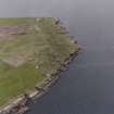
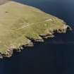
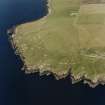
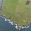
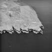
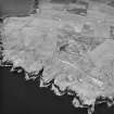
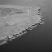
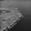
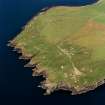
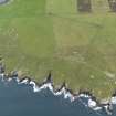
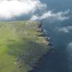
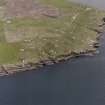
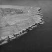
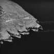
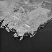
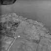
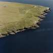
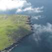
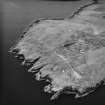
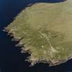
South Ronaldsay, Hoxa Head, Hoxa Battery


Coastal Battery (Second World War), Coastal Battery (First World War)
Site Name South Ronaldsay, Hoxa Head, Hoxa Battery
Classification Coastal Battery (Second World War), Coastal Battery (First World War)
Alternative Name(s) World War I And Ii; Scapa Flow; Pentland Firth
Canmore ID 104548
Site Number ND49SW 27
NGR ND 40450 92584
Datum OSGB36 - NGR
Permalink http://canmore.org.uk/site/104548


- Council Orkney Islands
- Parish South Ronaldsay
- Former Region Orkney Islands Area
- Former District Orkney
- Former County Orkney
ND49SW 27.00 40450 92584
ND49SW 27.01 ND 40332 92822 and ND 40283 92867 Coast Battery; Gun- emplacements; Magazines (WW I 4")
ND49SW 27.02 Centred ND 4046 9774 Military Camp (WW II)
ND49SW 27.03 ND 40499 92610 Observation post (WW II)
ND49SW 27.04 ND 40426 92578 and ND 40455 92559 Gun-emplacements (WW II 6")
ND49SW 27.05 ND 40434 92583 and ND 40461 92571 Coast Battery; Gun- emplacements; Magazines (WW I 6")
ND49SW 27.06 ND 40465 92528, ND 40379 92535,ND40243 92908 Searchlight Battery WW I and II)
ND49SW 27.07 ND 40526 92602 Engine house (WW II)
ND49SW 27.08 ND 40426 92645 Engine house (WW II)
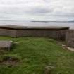
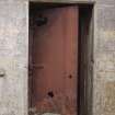
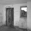
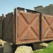
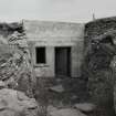
Hoxa Battery: A twin 4-inch gun First World War battery lies to the N (ND49SW 27.01). The WWII battery overlies a WWI 6-inch emplacement. During the Second World War this battery continued using this calibre of gun and was reduced to care and maintainance in 1943. The magazines, observation post, engine room and searchlight platforms can still be seen. The steel supporting the overhead cover is badly rusted and is likely to collapse soon.
J Guy 1993; NMRS MS 810/2; WO/192/263 PRO.
Three coast batteries are situated on the southern part of Hoxa head, two First World War and one Second World War installations.
The First World War gun-emplacements are of the open mount type with rock cut trenches leading to earth covered ammunition magazines 25m to the rear. There are four concrete emplacements to the N (ND49SW 27.01), and two immediately to the rear of the Second World War gun emplacements, the latter having been partially demolished.
Field Visit (August 1997)
Hoxa Head is strategically located for monitoring access into Scapa Flow through Hoxa Sound and Coastal Batteries were operational here during both world wars. Hoxa Battery became operational in 1915. It was equipped with four 4'' Quick Fire guns. Located on the east-facing coast of the headland, it operated in conjunction with Stanger Battery on Flotta to defend Hoxa Sound. A second battery was built in 1916; this faced S to cover the entrance to Switha Sound and was armed with two 6'' Quick Fire guns.
Hoxa Battery was re-established in 1939 with the emplacement of two 6'' Breech Loading guns and the construction of a range of ancillary buildings including an extensive camp. The new battery was located on the south coast of the headland and was charged with guarding access to Hoxa Sound and remained in use until 1943.
Balfour Battery was brought into being in 1940 to defend Hoxa boom. Initially, two twelve-pounder guns were temporarily emplaced c.300m to the N of Hoxa Battery. By 1941 two twin six-pounder guns were permanently installed The battery remained in use until 1945.
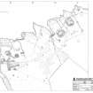
The lists below represents the most significant elements associated with the batteries which lie within 50m of the coast. They are described as they occur moving from north to south.
Balfour Battery [ND49SW 19]:
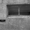
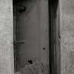
(i) Two concrete searchlight emplacements, lying 15m apart, are located 2m from the cliff edge. Access is via a set of steps leading down to a single doorway in the S side. The front of the structure has three slit openings, producing a dispersed beam when operational. They measure 5m by 3.5m and stand to 2.5m high. They both retain some internal fixtures and wall paint.
(ii) A searchlight emplacement, similar to (i) is located 5m from the coast edge, adjacent to a modern lighthouse. A wooden door has been added and the windows have been blocked up; it is currently in use as a store.
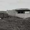
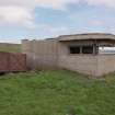
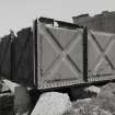
(iii) The northernmost of the twin six-pounder gun emplacements is located on the edge of a steeply sloping cliff. The gun was housed to the centre of the concrete structure, with a covered walkway and a range of stores surrounding it. A directing tower, several shelters and a magazine building are located to the rear. It was noted that exposed iron beams are now very corroded and parts of this structure may be structurally unsound.
(iv) The second, southern battery, is similar in all respects to (iv) above.
Features associated with either Balfour or Hoxa Batteries (located at ND 4032 9295) :
(v) A horseshoe-shaped earthen bank, built against a natural slope lies 25m from the cliff edge. It measures 9m by 5m and stands up to 1m high.
(vi) A concrete plinth, measuring 3.2m by 1.5m, lies 25m from the cliff edge.
(vii) A linear earthen bank extends for 5m and is up to 1.5m wide. It is located 20m from the cliff edge.
WWI & II Hoxa Battery [ND49SW 27]:
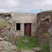
(viii) A searchlight emplacement, located on the cliff edge, is entered via a door in the S wall. The front of the structure is badly damaged and is now completely open. It measures 5m by 3.5m and stands to 2.5m high.
(ix) The northernmost of two WWI 4'' gun emplacements is located within 10m of the cliff edge. The front of the complex comprises two concrete barriers set c.10m apart, behind which the guns would have been set. Each gun position is linked, via a semi-subterranean passage, to a magazine building at the rear.
(x) The second WWI gun emplacement is located 30m S of (x) and is identical in form.
(xi) A rectangular pit, measuring 13m by 8m, is cut into the ground surface 10m from the cliff edge. Two narrow linear cuts lead off from either end. This hollow may have housed a storage tank with attached pipelines or drains.
(xii) A rectangular depression may represent the remains of a semi-subterranean structure. It measures 13m by 7m, is located 20m from the coast edge. Collapsed stonework to the N side of the depression apparently derives from a hearth and chimney.
(xiii) The remnants of a structure, which comprise a concrete floor and fragmentary drystone walls, are located 10m from the cliff edge. The floor covers a 36m2 area and there are indications of an entrance to the N side.
(xiv) A searchlight emplacement lies 2m from the cliff edge. It measures 5m by 3m and stands to 3m high. The front has a single large opening with 1800 field of vision.
(xv) The WWI 6'' gun emplacements have been disturbed and obscured by the WWII structures. Fragments are still visible, located within 20m of the cliff edge. (xvi) Two concrete WWII gun emplacements, which housed 6'' Breech Loading guns, are located 50m from the coast edge. They are surrounded by a range of buildings which include two magazines, two shelters, and the battery observation post. A track leads downhill from the gun emplacements to the camp area.
(xvii) A searchlight emplacement, similar to (xv), is situated to the SW of the gun emplacement (xvii).
(xviii) An artificial rectangular hollow in the cliff side may have housed storage tanks or a semi-subterranean structure. The cut, which extends into bedrock, measures 20m by 6m and is up to 2m deep in places. A small concrete plinth is located towards the centre of the area.
Moore and Wilson, 1997
Coastal Zone Assessment Survey
Project (March 2013 - September 2013)
A project to characterise the quantity and quality of the Scottish resource of known surviving remains of the First World War. Carried out in partnership between Historic Scotland and RCAHMS.

