
Pricing Change
New pricing for orders of material from this site will come into place shortly. Charges for supply of digital images, digitisation on demand, prints and licensing will be altered.
Upcoming Maintenance
Please be advised that this website will undergo scheduled maintenance on the following dates:
Thursday, 9 January: 11:00 AM - 3:00 PM
Thursday, 23 January: 11:00 AM - 3:00 PM
Thursday, 30 January: 11:00 AM - 3:00 PM
During these times, some functionality such as image purchasing may be temporarily unavailable. We apologise for any inconvenience this may cause.
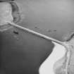
Martis: East Weddell Sound, Scapa Flow, Orkney


Craft (20th Century), Obstruction (Period Unassigned), Steamship (20th Century)
Site Name Martis: East Weddell Sound, Scapa Flow, Orkney
Classification Craft (20th Century), Obstruction (Period Unassigned), Steamship (20th Century)
Alternative Name(s) William Balls; East Weddel Sound; Churchill Causeway; Churchill Barrier No. 3; North Sea; Martis; Martis (Ex. William Balls)
Canmore ID 102355
Site Number ND49NE 8011
NGR ND 4731 9848
Datum WGS84 - Lat/Long
Permalink http://canmore.org.uk/site/102355


- Council Orkney Islands
- Parish Maritime - Orkney
- Former Region Orkney Islands Area
- Former District Maritime
- Former County Not Applicable
ND49NE 8011 4731 9849
N58 52.2583 W2 54.82
NLO: Weddell Sound [name centred ND 477 988]
Stromness [name: HY 253 090]
Scapa Flow [name centred HY 36 00].
For possible detached stern of the Martis (cited seperately by Whittaker) at ND 4746 9843 (N58 52.23 W2 54.67), see ND49NE 8044.
Formerly entered as ND49NE 8900.
For adjacent and successor causeway (Churchill Barrier no. 3), see ND49NE 16.
For other blockships in this group, see ND49NE 8001, ND49NE 8010, ND49NE 8012 -13.
For plan indicating the relative locations and orientations of blockships in this group, see Macdonald 1990, 125.
Horizontal Datum = OGB
Buoyage =
Circumstances of Loss Details
-----------------------------
Single-screw steamer MARTIS, built in 1894, sunk as a blockship. Registered London, built at South Shields.
Source: Ferguson 1985
Surveying Details
-----------------------------
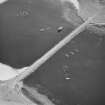
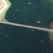
14 March 1972. The wreck's position is given as 68 52 13N, 002 54 50W, or bearing 182 degrees, 670 metres from Glimp Holm trig station (97). The stern and bows have been cut off and removed. There is no sign of the engines but all the fittings exist. However a blue trawler has since blasted the wreck. The rest of ship is an empty shell standing in 6 metres of water. It is proud of the surface and very strong. The keel lies roughly on an oreintation of 135/315 degrees.
Report by Undermarine Operations, 5 March 1972.
2 March 1976. Three small rectangular blocks are showing above the level of mean low water, centred on 58 52 15.5N, 002 54 49.2W and extending for a length of about 50 metres. The three blocks are in line broadside to broadside and orientated 174/354 degrees.
Source: Ordnance Survey aerial photography dated 16 May 1973.
27 August 1992. The stern and bows have been cut off and removed. The remaining sections are visible at low water.
Source: MacDonald 1990; Ferguson 1985
Hydrographic Office, 1995.
(Classified as steel steamship: former name cited as William Balls, and date of loss as 14 June 1940). Martis: this vessel was scuttled as a blockship. Bow and stern removed?
Registration: London. Built 1894. 2483grt. Length: 91m. Beam: 12m.
(Location of loss cited as N58 52.25 W2 54.82).
I G Whittaker 1998.
Field Visit (August 1997)
Throughout the two World Wars Scapa Flow served as the base of the British Home Fleet. Access to these waters was guarded by a series of coastal batteries, booms and blockships. The blockships comprised old and damaged vessels which were deliberately sunk in position so as to form a submarine obstacle to deter enemy incursions. By 1943, the completion of the Churchill barriers, which cut off the eastern approaches to Scapa Flow, rendered the blockships obsolete. After 1945 some of the blockships were dispersed by explosive to clear the shipping lanes while many others were salvaged for parts and metal. The wrecks of several blockships remain on the sea bed and in the inter tidal zone.
(i) To the E side of Churchill Barrier #3, the wreck of the Reginald (ND 49 NE 8010) lies in shallow water. This 930 tons iron three-masted motor schooner was built in 1878 in Glasgow and was sunk in 1915. The stern section of the hull is visible above the water line.
(ii) The Lapland (ND 49 NE 8013), a 1,234 ton steel single-screw steamer was built in Dundee in 1890 and registered in Liverpool. Little of this blockship is now visible, since the barrier was constructed over it.
(iii) The Gartshore (ND 49 NE 8012), a 1,564 tons iron single-screw steamer, was built and registered in South Shields. She lies to the W side of the barrier.
(iv) The Martis (ND 49 NE 8011), a 2,483 ton steel single-screw steamer, was built in South Shields in 1894. She lies to the W side of the barrier.
(v) The Empire Seaman (ND 49 NE 8001) )was a steel single-screw steamer of 1,921 tons. Built in Lubeck in 1922, she was seized by the Royal Navy in 1940 and sunk as a blockship. She lies to the W side of the barrier.
Moore and Wilson, 1997
Coastal Zone Assessment Survey
Reference (2011)
Whittaker ID : 193
Name : MARTIS (EX. WILLIAM BALLS)
Latitude : 585215
Longitude : 25449
Date Built : 1894
Registration : LONDON
Type : SS (STEEL)
Tonnage : 2483
Tonnage Code : G
Length : 91
Beam : 12
Draught : 5m
Position : Exact Position
Loss Day : 14
Loss Month : 6
Loss Year : 1940
Comment : Scuttled as blockship. Bows and stern removed?
Reference (19 April 2012)
UKHO Identifier : 001255
Feature Class : Obstn
State : LIVE
Classification : Unclassified
Position (Lat/long) : 58.87005,-2.91530
Horizontal Datum : ETRS 1989
WGS84 Position (Lat/long) : 58.87005,-2.91530
WGS84 Origin : Original
Previous Position : 58.87097,-2.91367
Position Quality : Precisely known
Depth Quality : Depth unknown
Water Depth : 2
Vertical Datum : Lowest Astronomical Tide
Name : MARTIS
Type : BLOCKSHIP
Flag : BRITISH
Tonnage : 2483
Tonnage Type : Gross
Date Sunk : 14/06/1940
Contact Description : Notable debris
Original Sensor : Reported Sinking
Last Sensor : Acoustic Sensor
Original Detection Year : 1940
Last Detection Year : 2010
Original Source : Other
Last Source : Survey Vessel
Circumstances of Loss : **STEEL SINGLE-SCREW STEAMER, BUILT 1894, SUNK AS A BLOCKSHIP. (WKS OF SCAPA FLOW).
Surveying Details : **H2496/72 14.3.72 POSN 685213N, 025450W, OR 182DEG, 2200FT FROM GLIMP HOLM TRIG STN (97). STERN AND BOWS HAVE BEEN CUT OFF AND REMOVED. NO SIGN OF ENGINES BUT ALL FITTINGS EXIST, BUT A BLUE TRAWLER HAS SINCE BLASTED THE WK. REST OF SHIP IS AN EMPTY SHELL STANDING IN 20FT OF WATER, PROUD OF SURFACE AND VERY STRONG. LIES ROUGHLY NW/SE. (UNDERMARINE OPERATIONS 5.3.72). INS AS DWPA. BR STD.
**H1270/76 2.3.76 THREE SMALL RECTANGULAR BLOCKS SHOWING ABOVE THE LEVEL OF MLW, CENTRED ON 585215.5N, 025449.2W AND EXTENDING FOR A LENGTH OF ABOUT 50MTRS. THE THREE BLOCKS ARE IN LINE BROADSIDE TO BROADSIDE AND ORIETATED 174/354DEGS. (ORDNANCE SURVEY AERIAL PHOTOGRAPHY 73/137 DTD 16.5.73 FOR PHOTOPLOT PG PG 1428-LP1).
**3.7.80 COVERED BY LEGEND: 'OBSTRUCTION - SEE NOTE' ON NCS 35, 2165.
**27.8.92 STERN & BOWS CUT OFF & REMOVED. REMAINING SECTIONS VISIBLE AT LOW WATER. (DIVE SCAPA FLOW, WKS OF SCAPA FLOW).
POSITIONS BELOW THIS POINT ARE IN DEGREES, MINUTES AND DECIMALS OF A MINUTE
**5.10.10 LOCATED IN 5852.2032N, 0254.9179W [WGD]. LEAST M/B DEPTH 1.1MTRS. (FATHOMS LTD, POST SDC BATHY REPROCESSING). DATA NOISY AND COVERAGE POOR. AMEND POSN. COVERED BY LEGEND: 'OBSTRUCTIONS'. NCA.
Chart Symbol : OB
Charting Comments : LEGEND: 'OBST'N - SEE NOTE', OBSTN NOT CHARTED
Date Last Amended : 05/10/2010
Date Position Last Amended : 05/10/2010
Reference (March 2012)
Sitename : Martis: East Weddell Sound, Scapa Flow, Orkney
Source :
Scapa Flow East in WGS1984 at 2m resolution Bathymetry Id 2010-27833_ScapaFlowArea2a_2m_SB_WGS84.bag,Fathoms Ltd,2010
Project (2013 - 2014)
The Scapa Flow 2013 Marine Archaeology Survey Project, commissioned by Historic Scotland, undertook remote sensing surveys and archaeological diving evaluations at some of the sites within Scapa Flow, Orkney and at the Churchill Barriers.
The project aimed to establish or confirm the identification, extent of survival, character and condition of around 28 known but mostly poorly recorded First and Second World War wreck sites, 8 salvage sites, several sites thought to be associated with Second World War Boom Defences, and a limited sample of geophysical features identified in previous studies (Project Adair).
The work built on that of previous surveys including those completed as part of the ScapaMap Project (2001 and 2006) and by Wessex Archaeology Scapa Flow Wrecks Survey (2012), amongst others.
The project was completed by ORCA Marine and SULA Diving
Diver Inspection (2013)
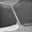
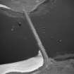
58 52.203 N 2 54.918 W The remains of a vessel measuring about 65m long by 12m beam lie on a rocky bottom in 0m – 7m of water. The wreck is oriented northwest to southeast with the stern to the southeast. It appears that the bow and stern sections have been salvaged.
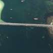
The submerged wreckage has a light covering of short animal turf. The remains can be affected by slight swells but are generally sheltered from tide.
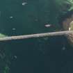
The submerged debris to the stern comprises several large sections of steel ribs and plates, some of which have weight saving apertures. A valve chest with nine valves was also noted.
Parts of the midships section are visible above the water at low tide. There was no evidence of an engine or boilers. Assessment of the visible surface remains indicates the presence of concrete ballast in the fore and aft holds.
Within the broken down wreckage of the bow, a portion of chain, a cleat and several smaller hull fragments laying flush with the seabed were recorded in the debris. There were some lines and an abandoned creel in the wreckage.
Analysis
Historical documents and image confirm that these are the remains of the SS Martis. The bow, stern andsuperstructure were salvaged by Metal Industries in the 1940s (Wood 2008).
A British steel steamship, the SS Martis was built as the SS William Balls for W. D. C. Balls & Son, North Shields in 1894 by Readhead John & Sons Ltd., South Shields. The vessel was renamed the SS Martis in 1929 when bought by Tramp Shipping Development Co., Ltd., London. Purchased by the Admiralty in 1940, the Martis was scuttled as a Blockship in East Weddell Sound on the 14th June 1940.
Information from Annalisa Christie, Kevin Heath and Mark Littlewood (ORCA) March 2014
Side Scan Sonar Survey (2013)
58 52.203 N 2 54.918 W The site was assessed by side scan surveys using a pole-mounted towfish and diver ground-truthedT. he exposure of the remains above the water made scanning the site difficult and the images of the remains are not very clear.
Information from Annalisa Christie, Kevin Heath and Mark Littlewood (ORCA) March 2014

