
Collingdoc: Water Sound, Scapa Flow, Orkney


Craft (20th Century), Steamship (20th Century)
Site Name Collingdoc: Water Sound, Scapa Flow, Orkney
Classification Craft (20th Century), Steamship (20th Century)
Alternative Name(s) Collindoc; D B Hanna; Ayre Of Cara; Churchill Causeway; Churchill Barrier No. 4; North Sea; Collingdoc; Collingdoc (Ex. D B Hanna)
Canmore ID 102209
Site Number ND49NE 8005
NGR ND 47925 95005
Datum WGS84 - Lat/Long
Permalink http://canmore.org.uk/site/102209


- Council Orkney Islands
- Parish Maritime - Orkney
- Former Region Orkney Islands Area
- Former District Maritime
- Former County Not Applicable
ND49NE 8005 4792 9500
N58 50.385 W2 54.1383
NLO: Water Sound [name centred ND 460 950]
Ayre of Cara [name: ND 476 949]
Stromness [name: HY 253 090]
Scapa Flow [name centred HY 36 00].
Formerly entered as Site no. 8744.
For adjacent (and successor) Churchill Barrier No. 4, see ND49NE 17.
For other blockships in this group, see ND49NE 8002-4, 8006-9 and 8022, and ND49SE 8001.
For plan indicating the relative locations and orientations of blockships in this group, see Macdonald 1990, 125.
Quality of fix = PHOT
Horizontal Datum = OGB
Orientation of keel/wreck = 034214
Circumstances of Loss Details
-----------------------------
The steel single-screw steamship COLLINGDOC was sunk as a blockship, after seeing many years service as a Great Lakes steamer.
Source: Ferguson 1985
Surveying Details
-----------------------------
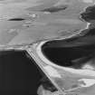
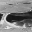
14 March 1972. The wreck's position is given as 58 50 23N, 002 54 11W, or bearing 198 degrees, 792 metres from the spot height (107) on Burray. The bows to the midships is intact, with bows towards the beach. The bridge is missing but there is a concrete construction on the bows, about 6 metres high, which was possibly gun emplacement at one time. The hold is full of concrete and rocks. The engine room has been cleared out. There is no chance of the hull breaking up naturally for a long time, as it is in a strong state. The gunwhale is above water and shows about 1.2 metres high at highwater.
Report by Undermarine Operations, 5 March 1972.
9 March 1976. A large wreck shows above the level of mean low water at 58 50 23.1N, 002 54 08.3W. It is approximately 75 metres long and the keel is orientated 034.5/214.5 degrees.
Source: Ordnance Survey aerial photography dated 16 May 1973.
The wreck is well embedded in the sand at the SE end of the barrier, with the bridge and bow section showing at low water.
Source: MacDonald 1990
Hydrographic Office, 1995.
(Classified as steel steamship: former name cited as D B Hanna, and date of loss as 28 March 1942). Collingdoc: this vessel was sunk as a blockship at Scapa after being mined (13 July 1941) near Southend Pier [Thames estuary].
Registration: British. Built 1925. 1780grt. Length: 77m. Beam: 13m.
(Location of loss cited as N58 50.38 W2 54.13).
I G Whittaker 1998.
Water Sound is the most southerly of the four sounds that pierce the Eastern side of Scapa Flow. It formerly separated the islands of Burray (to the N) and South Ronaldsay (to the S), but is now crossed by Churchill Barrier No. 4 (ND49NE 17), which blocks it near the E (North Sea) end.
Information from RCAHMS (RJCM), 2 April 2007.
Desk Based Assessment (August 1997)
Throughout the two World Wars Scapa Flow served as the base of the British Home Fleet. Access to these waters was guarded by a series of coastal batteries, booms and blockships. The blockships comprised old and damaged vessels which were deliberately sunk in position so as to form a submarine obstacle to deter enemy incursions. By 1943, the completion of the Churchill barriers, which cut off the eastern approaches to Scapa Flow, rendered the blockships obsolete. After 1945 some of the blockships were dispersed by explosive to clear the shipping lanes while many others were salvaged for parts and metal. The wrecks of several blockships remain on the sea bed and in the inter tidal zone.
(i) The Pontos (ND 49 NE 8002), a 3, 265 ton steel single-screw steamer was built in Glasgow in 1891. She was sunk in 1914 and now rests c.12m offshore to the SE of Water Sound.
(ii) The Clio (ND 49 NE 8006), a 2,733 ton steel single-screw steamer was built in Hartlepool in 1889. She was sunk in 1914 and is visible to the centre of Water Sound at low tide.
(iii) The Lorne (ND 49 NE 8008), a 1,186 ton single-screw steamer was built in Hull in 1873 and sunk in 1915. The wreck was later dispersed by explosives and only fragments now survive.
(iv) The Naja (ND 49 NE 8008), a concrete barge, was sunk in 1939 and lies to the centre of Water Sound.
(v) The Carron (ND 49 NE 8004), a 1, 017 ton single-screw steel steamer, was built in Dundee in 1894. She was sunk as a blockship in 1940 and now lies, partially buried under sand, to the NE side of Churchill Barrier #4.
(vi) The Juniata (ND 49 NE 8022), a twin-screw steel motor tanker, was built in Sunderland in 1918. Sunk in 1940, she now lies to the NE side of Churchill Barrier #4.
(vii) The Gondolier (ND 49 SE 8001) was a 173 ton paddle steamer built in Glasgow in 1866. Sunk in 1940, she now lies on the SE side of the barrier.
(viii) The Collingdoc (ND 49 NE 8005), a 1,1780 ton steel single-screw steamer was built in 1925 in Hill-on-Tees. She was sunk in 1942 and lies partially buried under the sand to the SE end of the barrier.
(ix) Unidentified wreckage (ND 49 NE 8003) stands above HWM.
Reference (2011)
Whittaker ID : 2529
Name : COLLINGDOC (EX. D B HANNA)
Latitude : 585023
Longitude : 25408
Date Built : 1925
Registration : BRITISH
Type : SS (STEEL)
Tonnage : 1780
Tonnage Code : G
Length : 77
Beam : 13
Draught : 5m
Position : Exact Position
Loss Day : 28
Loss Month : 3
Loss Year : 1942
Comment : Sunk as blockship at Scapa after being mined 13/7/1941 near Southend Pier
Reference (19 April 2012)
UKHO Identifier : 001245
Feature Class : Wreck
State : LIVE
Classification : Unclassified
Position (Lat/long) : 58.83975,-2.90231
Horizontal Datum : ORDNANCE SURVEY OF GREAT BRITAIN (1936)
WGS84 Position (Lat/long) : 58.83933,-2.90392
WGS84 Origin : 3-D Cartesian Shift (BW)
Position Method : Air photography
Position Quality : Unreliable
Depth Quality : Depth unknown
Water Depth : 5
Vertical Datum : Lowest Astronomical Tide
Name : COLLINGDOC
Type : BLOCKSHIP
Flag : BRITISH
Orientation : 34.0
Tonnage : 1780
Tonnage Type : Gross
Date Sunk : 28/03/1942
Contact Description : Entire wreck
Original Sensor : Reported Sinking
Original Detection Year : 1942
Original Source : Other
Circumstances of Loss : **EX-D B HANNAH. BUILT IN 1925 AT HILL-ON-TEES. TRIPLE EXPANSION ENGINE, SINGLE SHAFT. SUNK AS A BLOCKSHIP, AFTER SEEING MANY YEARS SERVICE AS A GREAT LAKES STEAMER. (WKS OF SCAPA FLOW & SIBI).
Surveying Details : **H2496/72 14.3.72 POSN 585023N, 025411W, OR 198DEG, 2600FT FROM SPOT HEIGHT (107) ON BURRAY. BOWS TO MIDSHIPS INTACT WITH BOWS TOWARDS BEACH. BRIDGE MISSING BUT CONCRETE CONSTRUCTION ON BOWS ABOUT 20FT HIGH, POSSIBLY GUN EMPLACEMENT AT ONE TIME. HOLD FULL OF CONCRETE AND ROCKS. ENGINE CLEARED OUT. NO CHANCE OF HULL BREAKING UP NATURALLY FOR A LONG TIME, IN STRONG STATE. GUNWHALE ABOVE WATER 4FT HIGH AT HW. (UNDERMARINE OPERATIONS, 5.3.72). INS AS STF. BR STD.
**H1270/76 9.3.76 LARGE WK SHOWS ABOVE THE LEVEL OF MLW IN 585023.1N, 025408.3W. APPROX 75MTRS LONG AND ORIENTATED 034.5/214.5DEG. THIS WK COINCIDES WITH THE 'COLLINGDOC' ON SURVEY [E8535/5]. (ORDNANCE SURVEY AERIAL PHOTOGRAPHY 73/137 DTD 16.5.73 FOR PHOTPLOT PG 1482-LP1).
**20.8.80 COVERED BY 'BLOCKSHIPS SEE NOTE' LEGEND ON NE 2162.
**1.9.92 WELL EMBEDDED IN SAND AT SE END OF BARRIER, WITH BRIDGE & BOW SECTION RISING OUT OF THE BEACH & DRY AT LW. BRIDGE SET AT RIGHT ANGLES TO BOW, A STYLE COMMON TO MANY INLAND STEAMERS. BRIDGE IS STILL LINED WITH CONCRETE WHICH WAS A CHEAP EFFECTIVE WAY OF ARMOURING HER. ANCHOR WINCH STILL SITS ON WOOD-LINED DECK. (DIVE SCAPA FLOW).
Charting Comments : POSN FOR FILING ONLY
Date Last Amended : 09/02/2005

