
Pricing Change
New pricing for orders of material from this site will come into place shortly. Charges for supply of digital images, digitisation on demand, prints and licensing will be altered.
Hunnigeo, Muckle Skerry


Settlement (Period Unassigned)
Site Name Hunnigeo, Muckle Skerry
Classification Settlement (Period Unassigned)
Alternative Name(s) Pentland Skerries; Pentland Firth
Canmore ID 9513
Site Number ND47NE 9
NGR ND 4607 7830
Datum OSGB36 - NGR
Permalink http://canmore.org.uk/site/9513


- Council Orkney Islands
- Parish South Ronaldsay
- Former Region Orkney Islands Area
- Former District Orkney
- Former County Orkney
ND47NE 9 4607 7830.
Stone foundations and traces of kitchen middens 140yds NW of the head of Hunni Geo on Muckle Skerry (information from A Black, lighthouse keeper).
RCAHMS 1946
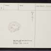
Evidently a domestic structure at ND 4607 7830, surviving as a roughly circular turf-covered mound 0.6m high. The centre has been mutilated by an amateur excavation (? by Black) revealing part of a complex structure of slabs on edge the plan of which cannot be fully determined. A few limpet shells occur amongst the debris.
Surveyed at 1/10,000.
Visited by OS (AA) 8 May 1973

