
Pricing Change
New pricing for orders of material from this site will come into place shortly. Charges for supply of digital images, digitisation on demand, prints and licensing will be altered.
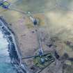
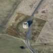
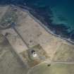
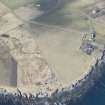
South Walls, Hackness, Martello Tower


Graffiti(S) (19th Century) - (20th Century), Martello Tower (19th Century)
Site Name South Walls, Hackness, Martello Tower
Classification Graffiti(S) (19th Century) - (20th Century), Martello Tower (19th Century)
Alternative Name(s) Scapa Flow; Longhope Anchorage; Hack Ness; Long Hope; Lyness; South Waas
Canmore ID 9496
Site Number ND39SW 8
NGR ND 33838 91277
Datum OSGB36 - NGR
Permalink http://canmore.org.uk/site/9496


First 100 images shown. See the Collections panel (below) for a link to all digital images.
- Council Orkney Islands
- Parish Walls And Flotta
- Former Region Orkney Islands Area
- Former District Orkney
- Former County Orkney
ND39SW 8 33838 91277
Martello Tower [NAT]
OS (GIS) MasterMap, August 2010.
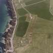
For associated coast defence battery (ND 3373 9149), see ND39SW 9.
For (associated) Martello tower at Crockness (ND 3242 9344), see ND39SW 10.
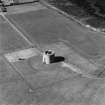
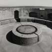
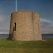
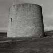
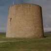
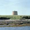
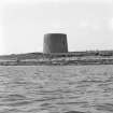
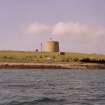
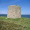
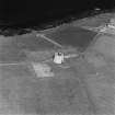
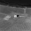
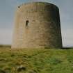
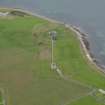
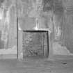
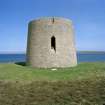
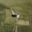
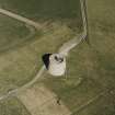
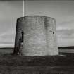
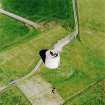
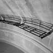
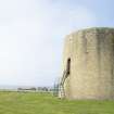
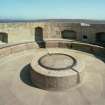
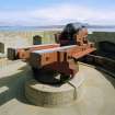
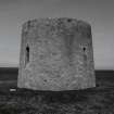
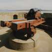
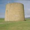
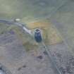
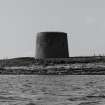
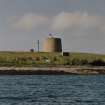
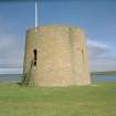
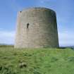
Martello Tower, Hackness. Built c.1812-18. On the roof, a circular iron track for the 68-pound gun that replaced the original 24-pounder in 1866.
J Gifford 1992.
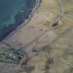
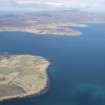
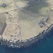
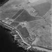
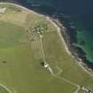
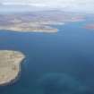
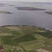
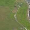
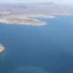
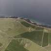
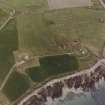
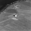
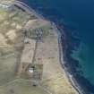
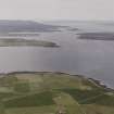
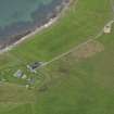
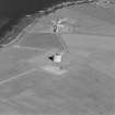
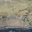
The two Martello towers at Hackness and Crockness (ND39SW 8 and ND39SW 10 respectively) were evidently constructed to cover the eastern entrance to the defended anchorage of Longhope, situated between the islands of Hoy and South Walls near the southern entrance to Scapa Flow. Their construction has traditionally been associated with the depradations of John Paul Jones.
Information from RCAHMS (RJCM), 4 September 1998.
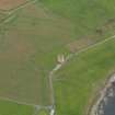
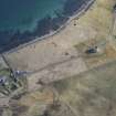
ND 3373 9149 to ND 3384 9128 The excavation of a water main trench was monitored at Hackness Gun Battery (NMRS ND39SW 9), on the island of Hoy. The trench was dug in September 2000, mostly by machine, partly by hand, and ran from the 19th-century battery (ND 3373 9149) to the Martello Tower (ND 3384 9128; NMRS ND39SW 8), a distance of some 110m.
No features were found outside the Martello Tower, except for the hard-core around the gateways, which is apparently of recent origin. The proximity of bedrock indicates that the tower was, unsurprisingly, built on solid foundations.
Two features in the field relate to the gun battery, the lightning conductor, and the drain immediately outside the battery wall, which may well replace an original drain. Inside the battery the layer of mortar and stone probably represents construction or demolition debris, the clay and stones below this may represent either natural subsoil, or, more likely, a redeposited dump, used as a level building platform.
A further watching brief was undertaken in May 2001 during the machine-excavation of three test trenches. No finds or features were noted.
The turf in a hand-dug trench was of very recent origin, and the rubble it overlay presumably represents building or demolition debris associated with the powder magazine. The slope to the base of this deposit probably represents the edge of the hole into which the magazine has been built, in an attempt to absorb the blast of any accidental explosion. The trenches revealed nothing of archaeological significance.
Sponsor: Historic Scotland
D Murray and G Ewart 2001.
Orkney Smr Note (August 1987)
This tower is the twin of the one at Crockness (OR 2045). It
was built 1813-15 in conjunction with the Hackness Battery
(OR 2050) to guard the Battery's rear while providing additional
fire across the approach to Long Hope anchorage. The tower was
reconstructed in 1866, within the same context as the re-arming of
the Battery, and provided with a new gun mounting.
[R1] [R2] [R3]
The Tower was taken into guardianship and restored between
1971 and 1987 and is now open to the public.
Information from Orkney SMR (RGL) August 1987.
Field Visit (August 1987)
Hackness Martello Tower ND 3384 9128 ND39SW 8
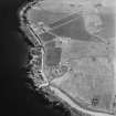
The tower was built contemporaneously with the Battery (ND39SW 9) to complement its fire and to provide some protection for the Battery's rear. It, too, was put back into a defensive state in 1866, when a new gun-mounting was installed on the roof. SDD has just completed a programme of restoration which has left this Tower in superb condition.
RCAHMS 1989, visited August 1987.
(Fereday 1971; Sutcliffe 1972, 133; Ritchie 1985, 22-3; OR 1969).
Publication Account (1996)
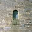
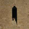
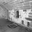
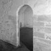
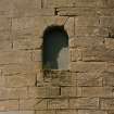
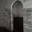
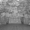
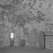
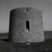
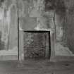
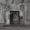
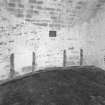
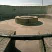
The tower appears to be circular, but the wall on the seaward side is twice as thick as that on the landward side in order to withstand bombardment,and this creates an elliptical plan. Inside, each of the floors is circular. Access into the tower is on the landward side at first-floor level, as a defensive measure; a single doorway, set at a height of about 4m above ground-level and reached originally by a portable ladder, leads into the living quarters for the gunners and their N.C.O. The tower had its own water-supply from a cistern built into the foundations, and the water could be raised to the living quarters by a hand-pump set into the recess on the left-hand side of the entrance passage. The beds were arranged radially round the wall, and the N.C.O. had the privacy of his own cubicle. Stairs within the thickness of the wall led down to the ground-level storeroom and magazine and up to the parapet and gun platform. At a height of some 10m above the ground, the top of the tower gives a wide view over the approaches to the Longhope anchorage, and the 24-pounder cannon could also guard the landward side of the battery against any attack from a landing party. The original gun mounting was modified in 1866, and the tower was used as a naval signal-post during the First World War.
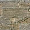
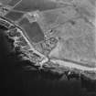
Less than 180m to the north-west of the tower lies the battery, designed as a powerful deterrent with eight 24-pounder guns sweeping the south-east approaches to Longhope through Switha Sound and Cantick Sound. The gunners were protected by a stone parapet and an embankment, while behind the battery were their barracks and stores and a magazine built partially underground, the whole installation enclosed within a high stone wall on the landward side. Most important of the extensive renovations carried out in 1866 was the remodelling of the battery itself to provide heavier guns and better protection for the gunners: four 68-pounder cannons were mounted so as to fire through embrasures rather than simply over the parapet. Additional domestic buildings include, beside the gate, an officers' block which later became a farmhouse. The sandstone used to build both the Hackness and Crockness martello towers and the battery was quarried at Bring Head on the northeast coast of Hoy and transported by boat to Longhope.
Information from ‘Exploring Scotland’s Heritage: Orkney’, (1996).
Watching Brief (4 September 2000 - 7 September 2000)
Kirkdale Archaeology were asked to monitor the digging of a water main trench at Hackness gun battery, on the island of Hoy, Orkney. The trench was dug over two days, mostly by machine, partly by hand, and ran from the battery (ND 337 915) to the Martello Tower (ND 338 913), a distance of some 110m.
No features were found outside the Martello Tower, except for the hard-core around the gateways, which is apparently of recent origin. The proximity of bedrock indicates that the tower was, unsurprisingly, built on solid foundations. The layer of sand got progressively thinner as the trench progressed to the SE, and uphill, which would correspond with this being a wind blown sand deposit, decreasing with distance from the sea. The small scatter of china in the field to the N of the track probably represents low intensity agricultural practices, with the brick built drain also serving an agricultural function. Two features in the field relate to the gun battery, the lightning conductor, and the drain immediately outside the battery wall, which may well replace an original drain. Inside the battery the layer of mortar and stone probably represents construction or demolition debris, the clay and stones below this may represent either natural subsoil, or, more likely, a redeposited dump, used as a level building platform.
Sponsor: Historic Scotland
G Ewart and D Murray 2000
Kirkdale Archaeology
Watching Brief (23 June 2016)
ND 3385 9128 A watching brief was undertaken, 23 June 2016, during the excavation of a small trench to allow the re-positioning of an existing sign near the approach road to Hackness Battery. The shallow excavation was carried out just N of the road, to the E of the Martello Tower. Nothing of archaeological interest was noted and bedrock was encountered at a depth of 170mm.
Archive: NRHE (intended)
Funder: Historic Environment Scotland
Andrew Hollinrake – Kirkdale Archaeology
(Source: DES, Volume 17)
Field Visit (24 May 2018)
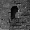
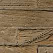
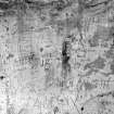
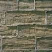
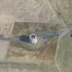
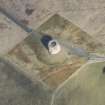
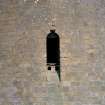
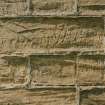
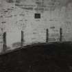
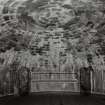
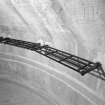
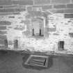
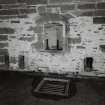
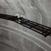
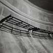
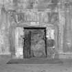
Extensive graffiti, mostly executed with a blade or sharp implement and mainly comprising names, initials and dates ranging from the 1890s to 2013, is visible within the tower. The majority of the graffiti is scratched or engraved into the lime-washed plastered walls, with most of it occurring on the upper staircase, which leads from the first floor towards the roof and gun emplacement, and a marked cluster close to the top of the staircase where the natural light falls through the doorway. The detail of the graffiti includes information about which boats people were working on, what rank they held, or where they were from. Except for one saltire there is no pictorial graffiti.
Visited by HES Survey and Recording (AGCH, LM) 24 May 2018.

