Pricing Change
New pricing for orders of material from this site will come into place shortly. Charges for supply of digital images, digitisation on demand, prints and licensing will be altered.
Switha, South
- Council Orkney Islands
- Parish Walls And Flotta
- Former Region Orkney Islands Area
- Former District Orkney
- Former County Orkney
ND39SE 1 3627 9070.
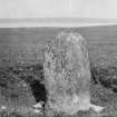
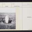
(ND 3627 9070) Standing Stone (NR)
OS 6" map (1900)
A stone 4ft 8ins high, 3ft average width and 12 1/2ins thick, set up in a small hollow and facing NNE and SSW. There are traces of packing at the base.
RCAHMS 1946
Standing stone, as described.
Visited by OS (RL) 15 June 1967


