
Whitegate


Structure (Period Unassigned)
Site Name Whitegate
Classification Structure (Period Unassigned)
Alternative Name(s) Wic 100
Canmore ID 89794
Site Number ND36SE 3.02
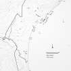
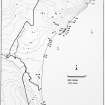
NGR ND 3545 6117
Datum OSGB36 - NGR
Permalink http://canmore.org.uk/site/89794


- Council Highland
- Parish Wick
- Former Region Highland
- Former District Caithness
- Former County Caithness
ND36SE 3.02 3545 6117
Dimensions, 14 x 8m, wall standing up to 0.5m; irregular stone structure aligned NW-SE, probably built from stone taken from the adjacent Whitegate broch or incorporating a broch outbuilding. Elevation c.10m. S aspect. WIC 100.
C Batey, Caithness Coastal Survey 1981
ND36SE 3.00 ND 3541 6120 Broch
ND36SE 3.01 ND 3549 6121 Structure
Project (1980 - 1982)
Field Visit (1981)
Dimensions, 14 x 8m, wall standing up to 0.5m; irregular stone structure aligned NW-SE, probably built from stone taken from the adjacent Whitegate broch or incorporating a broch outbuilding. Elevation c.10m. S aspect. WIC 100.
C Batey, Caithness Coastal Survey 1981

