
Scheduled Maintenance
Please be advised that this website will undergo scheduled maintenance on the following dates: •
Tuesday 3rd December 11:00-15:00
During these times, some services may be temporarily unavailable. We apologise for any inconvenience this may cause.
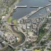
Wick, Harbour Bridge


Road Bridge (Period Unassigned)
Site Name Wick, Harbour Bridge
Classification Road Bridge (Period Unassigned)
Alternative Name(s) Wick, New Bridge; River Wick; Wick Harbour, Bridge; Wick Harbour, Swing Bridge; Wick Bridge; Wick River
Canmore ID 9207
Site Number ND35SE 69
NGR ND 36535 50952
Datum OSGB36 - NGR
Permalink http://canmore.org.uk/site/9207


- Council Highland
- Parish Wick
- Former Region Highland
- Former District Caithness
- Former County Caithness
ND35SE 69 36535 50952
Location formerly cited as ND 3650 5094.
Not to be confused with Bridge of Wick (ND 3622 5088), for which see ND35SE 60.
Wick Harbour Bridge is a recent concrete bridge of three spans with some decorative moulding.
G Nelson 1990.
This bridge carries the B9159 public road across the River Wick (Wick River) between Wick (to the N) and Pultneytown (to the S), within the town of Wick (ND35SE 81) and the area of Wick harbour (ND35SE 66.00).
The OS GIS ep. 4 notes a Swing Bridge, presumably a predecssor.
Information from RCAHMS (RJCM), 7 December 2000.

