
Garrywhin


Cairn(S) (Period Unassigned)(Possible)
Site Name Garrywhin
Classification Cairn(S) (Period Unassigned)(Possible)
Canmore ID 9064
Site Number ND34SW 56
NGR ND 31245 41418
NGR Description ND 31245 41418 and ND 31261 41448
Datum OSGB36 - NGR
Permalink http://canmore.org.uk/site/9064


- Council Highland
- Parish Wick
- Former Region Highland
- Former District Caithness
- Former County Caithness
ND34SW 56 31245 41418 & 31261 41448
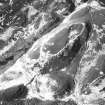
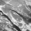
At ND 3124 4141 on the highest point of the hill within the Iron Age fort Garrywhin (ND34SW 3) is a cairn of bare stones recently exposed by heather burning. It measures about 4.5m in diameter and 0.3m high; no retaining kerb or cist is visible.
Some 30.0m to the NE is a mound of stones, 3.5m in diameter and 0.2m high. It is not dissimilar to the cairn, but its relatively sheltered position and lack of a definite cairn shape render its classification uncertain.
Surveyed at 1:2500.
Visited by OS (N K B) 16 December 1976.
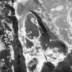
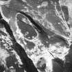
There are two heaps of stone within the NW part of the interior of the fort at Garrywhin (ND34SW 3). Although the location of the southwestern heap (YARROWS04 78) is not uncommon for a cairn, it seems to be no more than a collection of loose stones and boulders measuring 7.3m from N to S by 7m transversely. The second heap of stones (YARROWS04 79) is situated some 30m to the NE. Now partly embedded in the peat, it measures 3m in diameter and 0.1m in height.
(YARROWS04 78-9)
Visited by RCAHMS (ARG, ATW) 16 June 2004

