
Pricing Change
New pricing for orders of material from this site will come into place shortly. Charges for supply of digital images, digitisation on demand, prints and licensing will be altered.
South Yarrows, South


Chambered Cairn (Neolithic), Hut (Period Unassigned)
Site Name South Yarrows, South
Classification Chambered Cairn (Neolithic), Hut (Period Unassigned)
Alternative Name(s) Yarhouse
Canmore ID 9057
Site Number ND34SW 5
NGR ND 30463 43195
Datum OSGB36 - NGR
Permalink http://canmore.org.uk/site/9057


- Council Highland
- Parish Wick
- Former Region Highland
- Former District Caithness
- Former County Caithness
ND34SW 5 30463 43195.
(ND 3045 4318) Long Cairn (NR)
OS 1:10,000 map, (1976)
An Orkney-Cromarty type long horned cairn with a Camster-type chamber at the E end and a short passage in the S side which may have ended in the subsidiary chamber described by Tress Barry in 1900. The cairn was also excavated by Anderson in 1865. The cairn measures 240ft in length and varies in width from 36 to 66ft and in height from 5 to 12ft. The E end has been altered by the construction of modern walling outside the entrance and by the rebuilding of the walls and roof of the passage and outer compartment of the chamber.
A S Henshall 1963.
As described and planned by Miss Henshall.
Surveyed at 1:2500.
Visited by OS (N K B) 2 May 1967.
This cairn has a distinct 'head and tail' profile and a very short passage which indicate that it originated as a round, chambered cairn too small to effect the plan of the subsequent long cairn, which is probably relatively late in date.
A S Henshall 1972.
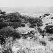
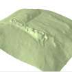
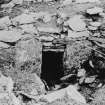
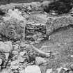
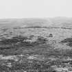
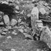
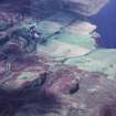
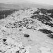
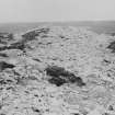
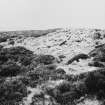
This is the southern of a pair of chambered cairns (YARROWS04 224) at South Yarrows, lying 160m SW of the farmsteading and 250m S of its neighbour to the N (ND34SW 6). The cairn stands on the crest of a broad, heather-grown ridge that slopes gently down from S to N and falls more steeply to the E and W. The cairn measures 58m in length from E to W by about 18.5m in breadth, increasing to 29m across the horns at its E end and about 18.4m across the horns at the W end. The cairn material rises up to 2m in height at the E end, where an axial burial-chamber is visible. The chamber is accessed by way of a passage that runs back into the body of the cairn from just N of the centre of the concave forecourt. This passage measures about 2m in length by 0.8m in width, and at its W end there is a pair of portal stones framing a narrow entrance 0.4m wide leading into an ante-chamber. The ante-chamber measures 1.6m in length by up to 1.8m in width, though the side-walls cannot now be seen due to modern dry-stone infilling. At the W end of the ante-chamber another pair of portal stones frame the entrance to the main chamber, which measures 3m in length by 1.8m in width. At the W end of the main chamber is a cell, which is still roofed with a large slab and measures 1.4m in length from N to S by 0.7m transversely. A large slab (YARROWS04 225), which measures at least 3m by 2m transversely and could have been a capping stone within this part of the cairn, lies 12m E of the NE horn of the cairn.
Situated roughly midway along the S side of the cairn are the remains of another roofed passage. It may have led to the wedge-shaped chamber found in 1900 by Tress Barry. This chamber was widest at its N end, where a large upright slab had been built into the rear wall, the southern two thirds was divided along its length by three close-set upright slabs supporting the capping stones. Today only part of a passage is visible. Partly roofed with slabs resting on walls of edge-set slabs and dry-stone walling, it measures 1.8m in length by 0.6m in width and 0.6m in height.
There are at least two other locations where the tops of large upright slabs in the body of the cairn suggest the possible presence of internal features. These are located at the W end and between the two recorded chambers, but at neither location was enough of the structure visible to allow a positive interpretation of the remains.
The visible remains of this cairn and the documentation that relates to the history of its 'exploration' strongly suggests that the E end of the cairn was originally a free-standing chambered round cairn with its chamber and passage aligned ESE and WNW. Later this was extended to the W to form a long cairn, but the axis of the latter is at least 12 degrees to the S of that of the chamber and passage.
What may be the remains of a small hut (YARROWS04 256) is situated on the top of a low rise 11m N of the W end of the cairn. It measures 3.5m in length from N to S by 2.5m transversely over a wall 0.5m in thickness and 0.2m in height. The wall is partly made up of small upright slabs.
(YARROWS04 224, 225, 256)
Visited by RCAHMS (AGCH) 30 June 2004
Publication Account (1995)
The whole trail from South Yarrows farm to the top of Warehouse Hill and back again takes some two hours or more, and involves steep climbs and some boggy areas, but the first two long cairns are quick and easy to reach. The trail is a mown path through heather, but the further cairns are off the path. Take this map or the trail leaflet with you to identify the cairns.
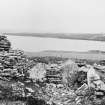
From the carpark go down to the loch (two stiles over fences) to see a broch with outer defences and outbuildings, 1. These were cleared out in 1866-7 but have since become somewhat ruinous and also partly flooded since the level of the loch was raised. There is a long chamber in the wall of the broch leading off the side of one entrance, and the stairs once rose opposite this. A later wall has been built round the inner side of the broch to make it into a house, and the second entrance may be connected with this. The outbuildings belong to this secondary phase and include long curved structures which had rows of upright slabs inside to support the roof, as at Forse Wag (no. 94). The whole site was cut off by a ditch and bank running out to the loch at each end.
Return to the start, and take the mown grassy path uphill through the heather to a series of cairns. Nearest to the carpark are two very long horned cairns which lie east-west across the flat top of the hill, some 30m apart. Both were excavated in 1865. The north cairn, 2, is somewhat overgrown with grass and heather and has a chamber at the higher east end where horns, not now visible, defined a semi-circular area in front of the entrance. This part of the cairn is divided by a narrow gap, possibly original, from a long rectangular extension with short horns at the west end. The south cairn, 3, a little higher up the hill, is 78m long and its horns are visible at both ends, as are traces of the wall-face that ran all round it. The chamber in the higher east end was divided into three compartments, the inner one still covered by a capstone, but there is confusing modern walling and dumps in the outer chamber and forecourt.
The trail then continues up to Warehouse Hill. The next site reached is a flat-topped hill with steep sides that seems to have been a fort, 4, though the defences are hard to see. There are slight traces of rampart footings on the west side, and a heather-covered bank and ditch on the south; the location is very similar to Garrywhin (see no. 95). Next comes a standing stone, 5, with a larger slab lying by it which may have split off its face. Erected in the 2nd millennium BC, it has more recently been used as a parish boundary marker. The prominent stone cairn highest up the hill is also bronze age (though until recently confused with a different neolithic cairn). A cist or stone-lined grave some 2.5 m long, with human bones and a bronze spearhead, was found in it in the last century, perhaps a warrior buried with his spear. Little can be seen now but a hole in the middle, and disfiguring modern marker cairns (please do not add to these).
Nearby is another neolithic chambered cairn, 7, apparently just a large round mound, but when the heather was burnt off in 1982 it was found to extend southwest as a long, low rectangle with horned ends. Part of the chamber can be seen. The last chambered cairn, 8, is now turf-covered. Many of the cairn stones have been removed and the whole passage and chamber with the dividing slabs lie open to view.
From Warehouse Hill the path descends back north towards the loch. Just before a square fenced enclosure are two hut circles, 9, one east and one west of the path, part of a scattered settlement; these are quite hard to see in the heather. The trail returns to the carpark passing west of the farmhouse.
From the carpark a pair of standing stones can be seen on the ridge east of the loch, where there is another chambered cairn. Also east of the loch at NO 312440 is a group of stone rows some 43m long, originally at least right rows set roughly parallel to one another, but now reduced to the remains of six, at a place called Battle Moss. These are only some of the early sites in the neighbourhood, and one wonders where the people who built all these monuments lived? Their tombs have been found but not their dwellings.
Information from ‘Exploring Scotland’s Heritage: The Highlands’, (1995).
Measured Survey (5 August 2004)
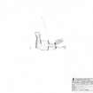
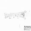
RCAHMS surveyed the long cairn at South Yarrows, South on 5 August 2004 with plane table producing a plan of the chamber at a scale of 1:50.
Measured Survey (30 September 2004)
RCAHMS surveyed the long cairn at South Yarrows, South on 30 September 2004 with plane table and self-reducing alidade producing a plan at a scale of 1:250. The plan was redrawn in vector graphics software as part of a comparative page showing two plans and a digital terrain model of the long cairn at a scale of 1:500.

