
Pricing Change
New pricing for orders of material from this site will come into place shortly. Charges for supply of digital images, digitisation on demand, prints and licensing will be altered.
Sarclet, The Loups


Battery (19th Century), Gun Emplacement (19th Century)
Site Name Sarclet, The Loups
Classification Battery (19th Century), Gun Emplacement (19th Century)
Canmore ID 91677
Site Number ND34SE 6
NGR ND 35319 43555
NGR Description ND 3530 4353 and ND 3533 4355
Datum OSGB36 - NGR
Permalink http://canmore.org.uk/site/91677


- Council Highland
- Parish Wick
- Former Region Highland
- Former District Caithness
- Former County Caithness
ND34SE 6 35319 43555
A Gun Battery and magazine is depicted on the 1st edition of the OS 6-inch map, (Caithness, 1881, sheet xxxiv) on the headland annotated 'The Loups'.
Information from RCAHMS (DE) 14 February 1996.
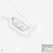
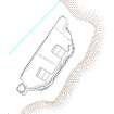
This battery, which was established in 1869, is situated on the cliff-top at The Loups, some 400m NE of Sarclet village (ND34SW 123), but it has been robbed of nearly all of its stone and all that can now be seen are grass-grown platforms, banks and robber-trenches. The battery faced SE onto the sea and its two original emplacements were protected by a parapet comprising a low wall with an earth ramp in front of it. The positions of the gun-emplacements (YARROWS04 532 & 533) are indicated by rectangular hollows set 9.3m apart, each measuring 6.2m from NW to SE by 3.8m transversely and 0.2m in depth. In both cases the floor of the emplacement bears the impressions of at least three sleeper beams, which have lain NE and SW. The parapet originally swung back at both ends, on the SW towards an ammunition magazine (YARROWS04 531) 7m SW of the southern emplacement, and on the NE to a small rectangular building (YARROWS04 534) 6.5m N of the northern emplacement. The magazine appears to have been partly buried and its site is now marked by a roughly oval hollow measuring 3.8m from NE to SW by 3.2m transversely and up to 0.5m in depth. The site of the building is indicated by a levelled stance measuring 6.1m from NE to SW by 3.2m transversely. The W corner of the building is linked to the N side of the magazine by a low, SE-facing scarp that might indicate that a wall or fence once ran across the rear of the battery.
The battery is depicted on the 1st edition of the OS 6-inch map (Caithness 1876, sheet xxx), and the annotation states that there were two guns. All that is shown on the 2nd edition of the map (1907, sheet xxx) is a representation of its surviving earthworks. The Ordnance Survey Name Book (Caithness, No. 13, p. 295) notes that the battery was used by the 6th Caithness Volunteer Artillery and that it lay on the estate of Captain Bentley Innes, Thrumster. An article in the Northern Ensign, dated April 1st 1869 describes the inauguration of the battery.
(YARROWS 04 531-534)
Visited by RCAHMS (JRS, IF) 29 July 2004
Measured Survey (12 August 2004)
RCAHMS surveyed the coastal gun battery at Sarclet on 12 August 2004 with plane table and self-reducing alidade at a scale of 1:250. The plan was later redrawn in vector graphics software at the same scale.

