
Castlehill Pavement Works


Pavement Works (19th Century)-(20th Century), Quarry (19th Century)-(20th Century)
Site Name Castlehill Pavement Works
Classification Pavement Works (19th Century)-(20th Century), Quarry (19th Century)-(20th Century)
Alternative Name(s) Castlehill Flagstone Museum; Castleton; Castletown Quarry
Canmore ID 8417
Site Number ND16NE 42
NGR ND 195 685
NGR Description Centred ND 195 685
Datum OSGB36 - NGR
Permalink http://canmore.org.uk/site/8417


- Council Highland
- Parish Olrig
- Former Region Highland
- Former District Caithness
- Former County Caithness
ND16NE 42.00 centred 195 685
For associated Castlehill Harbour (ND 1978 6858), see ND16NE 41.
ND16NE 42.01 1952 6860 Windmill
ND16NE 42.02 195 686 Pond
ND16NE 42.03 19250 68350 Quarry
ND16NE 42.04 194 687 Spoil Heap
ND16NE 42.05 18650 68250 Upper Quarry
ND16NE 42.06 1950 6869 Cottages
ND16NE 42.07 1957 6861 House
ND16NE 42.08 196 686 Offices
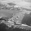
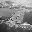
(Location cited as ND 195 685). Castlehill Pavement Works, early 19th century. The scattered remains of an extensive quarry, workmen's cottages (single storey) and dressing areas.
J R Hume 1977.
An extensive site which comprises flagstone quarries (ND16NE 42.03 and ND16NE 42.05 ), a cutting yard with machinery powered by water and steam (ND16NE 42.02), wind powered water pump (ND16NE 42.01), worker's housing (ND16NE 42.06), a farm steading (ND16NE 48), a harbour (ND16NE 41), the owner's manison house (ND16NE 40) and spoil heaps (ND16NE 42.04). The works was disused by 1914. Mush of the quarry has now been backfilled. All of the buildings at the cutting yard site have been demolished and cleared to ground level and all the machinery has been removed. The worker's houses are disused.
The Ordnance Survey 1st edition 25-inch maps of 1872 and 1905 (Caithness, sheet VI.10) show the extent of the flagstone quarry and the location of the works. The cutting yard was used to dress and saw the quarried stone before it was shipped from the harbour (ND16NE 41). By the early 1990s, part of the quarry, cutting yard, dam, water wheel pit, windmill stump and a portion of the steading have been transformed into a museum and interpretation centre. The ONB entry (1872) states that the works was powered by water and steam.
[See MS/744/63/1-5]
Visited by RCAHMS (GJD) November 1991
OS Name Book, 1872

