
Ferry Wood


Broch (Iron Age)(Possible)
Site Name Ferry Wood
Classification Broch (Iron Age)(Possible)
Alternative Name(s) Loch Shin
Canmore ID 5013
Site Number NC50NE 42
NGR NC 5719 0679
Datum OSGB36 - NGR
Permalink http://canmore.org.uk/site/5013


- Council Highland
- Parish Lairg
- Former Region Highland
- Former District Sutherland
- Former County Sutherland
NC50NE 42 5719 0679.
(NC 5719 0679) Broch (NR) (remains of)
OS 1:10,000 map, (1970)
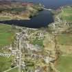
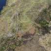
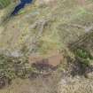
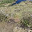
The remains of a broch on top of a natural hillock. It is slightly oval in shape measuring overall 15 x 14.0m. Stretches of the outer wall face are visible all round the perimeter generally formed by massive blocks of stone protruding from the turf to an average height of 0.3m. On the SE side one boulder stands 0.6m high. Only one stone likely to mark the inner wall face was noted in the rubble-strewn interior, giving a possible wall thickness of about 5.0m. On the N side a break in the outer wall face of 1.5m may indicate the end of the entrance passage. RCAHMS 1911; Visited by OS (W D J) 25 June 1963.
Forestry ploughing and planting have mutilated this broch; the course of the outer face is discernible, but many of of the facing stones are displaced. There is no trace of the inner face or mural cells, and the interior is strewn with stones.
Visited by OS (N K B) 13 August 1976.
Surveyed at 1/2500.
Visited by OS (J B) 16 March 1979.
Publication Account (2007)
NC5O 2 LOCH SHIN (‘Ferry Wood’)
NC/5719 0679
Probable broch in Lairg, Sutherland, standing on a natural hillock near the south-east end of Loch Shin. Stretches of the lowest course of the outer wallface are visible all round the perimeter, formed of massive stone blocks protruding from the turf; they indicate an oval plan, with maximum and minimum diameters of 15.0 by 14.0m [1]. There is a suggestion that the thickness of the wall at one point is about 5.0m The site was reported as “mutilated” in 1976 [1].
Sources: 1. NMRS site no. NC 50 NE 42: 2. RCAHMS 1911a, 135, no. 391.
E W MacKie 2007
Field Visit (20 July 2012 - 30 August 2012)
A desk-based assessment and walkover survey were carried out 20 July – 30 August 2012 on 29 sites in the North Highland Forest District. The work was undertaken in order to update existing monument management plans with new detailed site descriptions, condition reports, fixed point photography and plans (RCAHMS Level 4) of 25 scheduled monuments and one unscheduled monument. Three additional scheduled monuments were surveyed in greater detail, (RCAHMS Level 1). Recommendations were also made for the conservation management of the sites. The sites visited and surveyed were:
NH 728 784 (SAM 4760) Provost’s Well homestead and enclosure
NC 688 348 (SAM 2513) Noc na h’Iolaire hut circles and clearance cairns
NC 557 027 (SAM 1784) Ruim Baile Fuir stone circle, cairns, hut circles and enclosure
NC 679 390 (SAM 1779) Lach an Righ stone circle
NC 600 149 (SAM 5401) Loch Beag na Fuaralachd prehistoric settlement
NC 623 139 (SAM 5084) Achadh nan Eun shieling
NC 597 149 (SAM 5081) Loch Beag na Fuaralachd cairn and shielings
ND 212 372 (SAM 573) Rumster Broch
NH 786 942 (SAM 5484) Glen Cottage long cairn
ND 205 374 (SAM 550) Golsary Broch
NC 602 146 (SAM 5159) Loch Beag na Fuaralachd shielings
NH 730 798 (SAM 4752) Carn Liath long cairn
NH 731 786 (SAM 4743) Provost’s Well hut circles and field system
NC 689 392 (SAM 2517) Meall a Choire Bhuidhe hut circles
NH 772 926 (SAM 5573) Proncy hut circle
NC 696 334 (SAM 2519) Cnoc Airigh an Leathaid hut circles
NH 681 942 (SAM 4505) Creagan Reamhan farmstead, kiln and fields
NH 728 767 (SAM 2916) Scotsburn Wood cairn
NH 747 780 (SAM 3129) Lamington Park cairn
NH 734 834 (SAM 4763) Redburn Cottage long cairn
NH 396 628 (SAM 2720) Little Garve Bridge
NC 604 124 (SAM 5161) Meall Meadhonach sheepfold
NC 608 112 (SAM 4560) Meall Meadhonach hut circles, field system and shielings
NC 687 370 (SAM 2514) Cnoc na Gamnha hut circles, burnt mound and clearance cairns
NC 619 124 (SAM 5093) Meall Meadhonach settlement and shielings
NH 782 944 (SAM 1885) Skelbo Wood Broch
NC 591 103 (SAM 1829) Altbreck Broch
NC 592 102 (SAM 5563) Altbreck homestead
NC 571 067 Ferry Wood Broch
Funder: Forestry Commission Scotland
Steven Birch, West Coast Archaeological Services
Lynn Fraser, Ross and Cromarty Archaeological Services
Mary Peteranna, 2012

