
Scheduled Maintenance
Please be advised that this website will undergo scheduled maintenance on the following dates: •
Tuesday 3rd December 11:00-15:00
During these times, some services may be temporarily unavailable. We apologise for any inconvenience this may cause.
Allt Sgiathaig


Chambered Cairn (Neolithic)
Site Name Allt Sgiathaig
Classification Chambered Cairn (Neolithic)
Canmore ID 4650
Site Number NC22NW 1
NGR NC 23423 25520
Datum OSGB36 - NGR
Permalink http://canmore.org.uk/site/4650


- Council Highland
- Parish Assynt
- Former Region Highland
- Former District Sutherland
- Former County Sutherland
NC22NW 1 2341 2552
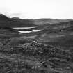
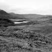
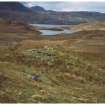
(NC 234 255) Allt Sgiathaig: The cairn is placed on a knoll at about 500' OD on a steep moorland hillside. It has a diameter of 35' and a height of c. 4'. Two slabs on its N edge have the appearance of being kerb stones, while the cairn seems to have spread to the NE and SW beyond its original limits. The NW side has been severely robbed and all traces of the passage, which apparently entered the chamber from this side, have probably been destroyed.
The chamber is partly ruined and filled with large slabs and debris. Two upright slabs on the W side, one slightly displaced forwards, are exposed to a height of nearly 3' and probably represent the portal stones between the passage and chamber. Two verticial but lower stones and two stretches of walling on the E side indicate a chamber c. 7' long by c. 5' wide.
A S Henshall 1963.
(NC 2341 2552) Chambered Cairn (NR)
OS 6"map, (1967)
Road improvements have caused the ground to be cut away to the very edge of the cairn on the NW side. It now seems more likely that the entrance to the chamber was on the SE side, giving the tomb a normal orientation. The edge of a flat stone revealed 5'6" from the chamber on this side might well be a lintel of the passage.
A S Henshall 1972, revisited 8 October 1963.
A ruinous chambered cairn recently slightly truncated on the W by roadworks. It is generally as planned by Henshall (A S Henshall 1963) but none of the stones can be considered kerb stones and the flat stone 5'6" from the chamber in the SE has been shown by a recent 'dig' to be loose in the debris and there is nothing to indicate the position of the entrance.
Visited by OS (J M) 15 August 1974.
No change to the previous field report.
Visited by OS (N K B) 6 June 1980.
Field Visit (26 November 2009)
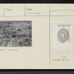
An uneven, sub-triangular grass covered cairn. Stones are visible in the structure but there is no sign of in situ construction. The mound is uneven and is now largely covered by moss, grass and heather; no entrance is apparent. There are signs of robbing and collapse on the NE side and the W side has been completely truncated by the road. The cairn sits on a slope, so that it is 3.5m high at the W and 1m high on the E; it is 2.5m high from the middle of the slope. Large stones are present on the top which are perhaps displaced lintels or capstones. There are up to 0.3m deep, 1m long and 0.5m high. The remainder of the stone rubble averages 0.3m x 0.2m and is sub-angular. A modern walkers' cairn has developed on the top.
(HLP_no 117)
Assynt's Hidden Lives Project 2009

