
Pricing Change
New pricing for orders of material from this site will come into place shortly. Charges for supply of digital images, digitisation on demand, prints and licensing will be altered.
Lewis, Lionel


Township (Period Unassigned)
Site Name Lewis, Lionel
Classification Township (Period Unassigned)
Alternative Name(s) Lionol, Lional
Canmore ID 129492
Site Number NB56SW 25
NGR NB 5300 6350
NGR Description Centred NB 5300 6350
Datum OSGB36 - NGR
Permalink http://canmore.org.uk/site/129492


- Council Western Isles
- Parish Barvas
- Former Region Western Isles Islands Area
- Former District Western Isles
- Former County Ross And Cromarty
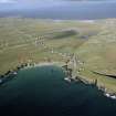
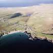
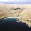
NB56SW 25 centred 5300 6350
The Object Name Book (OS) describes the township as 'A small village on the north side of the road from Stornoway to Port Chealagbhal (Ness). The houses are built of peat-moss and stone and thatched with straw and heather'.
Name Book 1852
A crofting township, comprising thirty-six roofed, one of which is annotated as 'ruin', three partially roofed annotated as 'ruins' and ten unroofed buildings is depicted on the 1st edition of the OS 6-inch map (Island of Lewis, Ross-shire 1853, sheet 3). To the SE is an extensive system of head-dykes (NB56SW 69) which may be partly associated with this crofting township.
A more extensive crofting township and field-system than that on the 1st edition is shown on the current edition of the OS 1:10000 map (1992).
Information from RCAHMS (AKK), 23 June 1997.

