
Pricing Change
New pricing for orders of material from this site will come into place shortly. Charges for supply of digital images, digitisation on demand, prints and licensing will be altered.
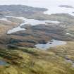
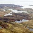
Lewis, Ceann Hurnavay


Head Dyke(S) (Post Medieval), Mill(S) (Period Unassigned), Township (Period Unassigned)
Site Name Lewis, Ceann Hurnavay
Classification Head Dyke(S) (Post Medieval), Mill(S) (Period Unassigned), Township (Period Unassigned)
Alternative Name(s) Ceann Thurnabhaigh
Canmore ID 132163
Site Number NB32NE 4.01
NGR NB 398 264
NGR Description centred on NB 398 264
Datum OSGB36 - NGR
Permalink http://canmore.org.uk/site/132163


- Council Western Isles
- Parish Lochs
- Former Region Western Isles Islands Area
- Former District Western Isles
- Former County Ross And Cromarty
Note
A township comprising eight roofed buildings, including two that are annotated as Mills [see: NB32NE 4.02], two unroofed buildings, one of which is annotated as a Ruin, several enclosures and a head-dyke is depicted on the 1st edition of the OS 6-inch map (Ross-shire, Island of Lewis 1854, sheet 33). This site is now located within the crofting township of Ceann Hurnavay as shown on the current edition of the OS 1:10000 map (1974).
Information from RCAHMS (SAH) 25 July 1997

