
Pricing Change
New pricing for orders of material from this site will come into place shortly. Charges for supply of digital images, digitisation on demand, prints and licensing will be altered.
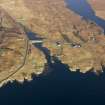
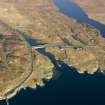
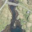
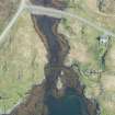
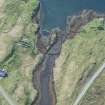
Great Bernera, Barraglom


Fish Trap(S) (Period Unassigned)
Site Name Great Bernera, Barraglom
Classification Fish Trap(S) (Period Unassigned)
Canmore ID 72851
Site Number NB13SE 19
NGR NB 16725 34427
Datum OSGB36 - NGR
Permalink http://canmore.org.uk/site/72851


- Council Western Isles
- Parish Uig
- Former Region Western Isles Islands Area
- Former District Western Isles
- Former County Ross And Cromarty
Note (October 1992)
Not to be confused with fish trap at NB 191 337, for which see NB13SE 8.
Scheduled (with NB13SE 5) as 'Dun Barraglom, broch, cup marked rocks, fish traps and settlement.'
Information from Historic Scotland, scheduling document dated October 1992.

