
Pricing Change
New pricing for orders of material from this site will come into place shortly. Charges for supply of digital images, digitisation on demand, prints and licensing will be altered.
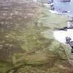
Lewis, Brenish, Mealista, Chain Home Radar Station


Radar Station (20th Century)
Site Name Lewis, Brenish, Mealista, Chain Home Radar Station
Classification Radar Station (20th Century)
Alternative Name(s) Brenais; Rubh' An Teampuill
Canmore ID 139410
Site Number NA92SE 18
NGR NA 99136 24239
NGR Description Centred NA 99136 24239
Datum OSGB36 - NGR
Permalink http://canmore.org.uk/site/139410


- Council Western Isles
- Parish Uig
- Former Region Western Isles Islands Area
- Former District Western Isles
- Former County Ross And Cromarty
NA92SE 18 centred 99136 24239
For the accommodation camp see NA92NE 9
A WWII Chain Home radar station is situated immediately NW of Mealista.
Information from Mr I Brown, November 1998
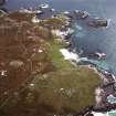
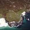
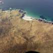
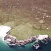
Situated on the W side of the road at Mealista is a WW II Chain Home Radar Station. A brick and concrete powerhouse, hut bases and a few mast stay anchor blocks are extant. The mast bases have been buried in recent years.
J Guy 2002; NMRS MS 810/12, 7-12
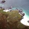
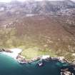
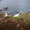
The Chain Home Low Radar station is situated on sloping ground the W side of a track leading to Mealista. The largest surviving structure is the brick and concrete main electricity generator house, with two extant engine 'beds' within. The building is now in use as an animal shelter. Immediately to the NE and SW of this building are concrete mast stay blocks with metal hoops for support wires.
Distributed around the site, notably at NA 99080 24298 and NA 99075 24204 are concrete hut bases. At NA 99149 24224, on top of a rocky knoll, is the delapidated base of a hut, supported on six brick pillars.
At NA 98963 24235 (obtained by using a hand held GPS Garmin) is what may be a small circular machine gun position guarding the rocky beach. One air-raid shelter is extant on the E side of the road at c.NA 9917 2427.
Brenais (Brenish) was completed in late 1942 and in service by 1943 (I Brown Radar Archive, PRO AIR 2/2667 and AIR 26/92) and closed in November 1945.
The radar station is visible on a RAF vertical air photograph (CPE/Scot/UK 186, 1429, flown 9 October 1946), which shows two large masts, transmitter (Tx) and receiver (Rx) blocks (NA 99081 24298 and NA 99075 24208), the generator house (NA 99136 24239) and about ten huts all situated on the W side of the road. The masts, visible on the air photographs, stood adjacent to the Tx and Rx blocks.
The accomodation camp was about 2.5km to the N (see NA92NE 9).
Visited by RCAHMS (DE, CS, SW), 3 August 2005

