
Pricing Change
New pricing for orders of material from this site will come into place shortly. Charges for supply of digital images, digitisation on demand, prints and licensing will be altered.
Fetlar, Sna Broch


Broch (Iron Age), Outworks (Prehistoric)
Site Name Fetlar, Sna Broch
Classification Broch (Iron Age), Outworks (Prehistoric)
Canmore ID 1390
Site Number HU59SE 1
NGR HU 57802 93332
Datum OSGB36 - NGR
Permalink http://canmore.org.uk/site/1390


- Council Shetland Islands
- Parish Fetlar
- Former Region Shetland Islands Area
- Former District Shetland
- Former County Shetland
HU59SE 1 5780 9334.
(HU 5780 9334) S na Brough (OE) (Site of)
O.S.6"map, Shetland, 2nd ed.,(1900).
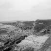
Sna Broch: A series of ramparts and ditches, evidently the defences of a broch which has been swept away by the sea.
The ramparts are still on average 6' to 7' high, and are spread at base from 12' to 13'.They have apparently been partly faced with stone, although the masonry is nowhere visible for more than two courses.
A well in the outer ditch, opposite a break in the inner rampart, is no longer visible but is noted by both Hibbert and Low.(From descriptions by G Low 1774 and S Hibbert 1822).
Abraded hammer-stones and fragments of broch- pottery were picked up at the time of visit.
The mound which lies outside the defences to the south is of indefinite character and its relationship to the larger construction is not clear.
RCAHMS 1946. Visited 1930.
Sna Brough, as described and planned by the RCAHM.
Visited by OS(NKB) 15th May 1969.
Field Visit (10 September 1930)
Broch, Sna Broch. Sna Broch stood on the Ness of Snabrough about half a mile to the N. of the landing-place near Brough Lodge, on the W. side of the island. The situation, and the resemblance of the remains to the outer defences of a broch, suggest that a broch once stood here, although the main building has evidently been swept away by the sea. Low, indeed, describes the remains as very unlike those of a broch, but it is probable that even in his time the tower had disappeared. He says of the place: ‘It is now much in ruins, owing to the falling away of the bank, but never has been circular; has consisted of a central oblong stonework, surrounded with a double ditch and wall’ (Tour, p.166).
In the main, Low's description tallies with what is visible to-day. The principal feature, i.e. the so-called " central oblong stone-work," which is not founded to such a depth or width as to suggest that it had formed part of a massive tower or building of broch-like proportions, is represented by the very fragmentary remains of a structure with an ogee-curved outline on plan. This may well represent part of the outer defences of a genuine broch, which has disappeared through coast erosion. The defensive ditches and ramparts or walls are on the E. or landward side. The ramparts are still, on an average, 6 or 7 ft. high, and are spread out to a breadth of 12 or 13 ft. at the base. They have apparently been partly faced with stone, although the masonry is not visible anywhere for more than two courses. There is an entrance gap through the outer rampart near its northern extremity, and on the S. this rampart curves sharply to join the inner one, which is broken at that end by a gap that led to a well in the outer ditch. The well is no longer visible, but it has been noted by Low and Hibbert.
Some abraded hammer-stones and pieces of characteristic broch-pottery were picked up at the time of visit, and there has also been found quite half of a small cooking-pot or vessel of baked clay, the fragments of which are now in the possession of the proprietor. An impossible suggestion made long ago by Hibbert (p.387) is responsible for the name of "Roman Camp" that is sometimes used of the site. The mound shown on Hibbert's plan outside the defences on the S. is of indefinite character, and it is not clear whether there is any connection between it and the larger construction.
RCAHMS 1946, visited 10 September 1930.
O.S.6"map, Shetland, 2nd ed., (1900).
Measured Survey (10 July 1934)
RCAHMS surveyed the broch and outworks at Sna Broch on 10 July 1934 by plane-table and alidade. The resultant plan and section were redrawn in ink and published at a reduced scale (RCAHMS 1946, fig. 542).
Publication Account (2002)
HU59 3 SNA BROCH 2 ('Sna Brough', 'Snaburgh') HU/578933
Possible broch on the west coast of Fetlar I., consisting of a segment of a series of ramparts and ditches most of which has been swept away by the sea. The remains suggest that the defences protected a broch but that this has completely vanished. The rampart fragments -- apparently partly faced with stone -- are still on average 1.83 - 2.14 m (6-7 ft.) high and 3.66 - 3.97 m (12-13 ft.) wide at base. The innermost defence -- a fragment of which remains at the edge of the cliff -- seems likely to be a piece of an outer defensive wall rather than of the broch itself [4]. A well used to be visible in the outer ditch [2, 3].
Sources: 1. OS card HU 59 SE 1: 2. Low 1774, 166: 3. Hibbert 1822, 387: 4. RCAHMS 1946, vol. 3, no. 1210, 55-6 and fig. 542.
E W MacKie 2002
Field Visit (19 May 2015)
A massive double bank and ditch flanking the eastern side of the site of a broch which has now completely eroded, except for a sliver of the eastern side of the broch mound. A circular mound at the southern end of the banks and ditches is presumably an element of the broch complex.
Erosion has exposed clean sections through the inner bank, the inner ditch and the central mound.
The banks and mound are constructed with up-cast material from the ditches, which buries and preserves the former soil horizon. Rare fragments of very decayed pottery were observed in the up-cast forming the mound. There is evidence of stone facing on the banks.
The section through the inner ditch has exposed a sequence of waterlogged and anaerobic silt and clay deposits at the base of the ditch containing preserved plant material. A mat of vegetation was observed at the base of one part of the ditch. These are sealed by boulder sized demolition debris, probably from the broch structures.
The potential for preservation of high quality paleao-environmental evidence from the buried soil horizons and the waterlogged ditch deposits is high.
Visited by Scotland's Coastal Heritage at Risk (SCHARP)
Note (1 April 2016 - 1 November 2016)
The Sna Broch has been reduced to no more than an arc of ramparts and ditches at the top of a beach. Sited on soft till deposits rather than the typical precipitous locations more usually adopted by promontory forts, there is now insufficient evidence to demonstrate whether these were simply the outworks of a broch or whether they incorporate elements of a promontory enclosure, the rocks lying some 70m offshore perhaps indicating its possible extent. Nevertheless, the arc includes the remains of at two ditches with external ramparts and it is likely that there was also a third rampart within the inner ditch rather than simply the wall of the broch (RCAHMS 1946, 55-6, no.1210, fig 542; MacKie 2002, 119); recent fieldwork along the shore has observed evidence of waterlogged deposits beneath rubble in the inner ditch. On the S the outermost rampart returns to meet the middle rampart, a configuration that possibly indicates that this was the site of an entrance, though the RCAHMS investigators attribute it to access to a well noted by earlier visitors in one of the ditches (Low 1879, 166; Hibbert 1822, 387). The RCAHMS plan drawn up in 1930 identifies a gap in the outer rampart at the N end of the arc as the remains of an entrance. Pottery and hammerstones have been recovered from the eroding section, including material from beneath one of the ramparts (Fojut 1983, 21).
Information from An Atlas of Hillforts of Great Britain and Ireland – 01 November 2016. Atlas of Hillforts SC4260

