
Pricing Change
New pricing for orders of material from this site will come into place shortly. Charges for supply of digital images, digitisation on demand, prints and licensing will be altered.
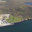
Kebister


Burnt Mound(S) (Prehistoric)
Site Name Kebister
Classification Burnt Mound(S) (Prehistoric)
Canmore ID 1020
Site Number HU44NE 7
NGR HU 4592 4566
Datum OSGB36 - NGR
Permalink http://canmore.org.uk/site/1020


- Council Shetland Islands
- Parish Tingwall
- Former Region Shetland Islands Area
- Former District Shetland
- Former County Shetland
HU44NE 7 4592 4566
See also HU44NE 4.
There is a cluster of at least six burnt mounds about 290m NE of Kebister settlement (HU44NE 5).
O Owen and C Lowe 1987.
The cluster of Burnt Mounds (1-6) lie at 15m OD, close to the shore and 20m SW of a dried up water-course. Burnt Mounds 1 and 2 had previously been recorded as 'Viking Graves' by P Moar (records held in Lerwick Museum) and as burnt mounds by P Winham (see HU44NE 4). They are considerably more prominent than Burnt Mounds 3-6.
Burnt Mounds 1 and 2 lie just a few metres apart and are similar in size, shape and form. Both are oval with with one concave side facing away from each other. An arc of large angular stones 1.5m long may indicate a possible wall-line half-way up the concave side of Burnt Mound 1.
Burnt Mounds 3-6 vary in size and form. Burnt Mound 3 is small and circular; 4 and 5 are amorphous and lie adjacent to a natural break of slope; 6 comprises a linear spread of burnt stones delimited on the W by several earth-fast boulders. Test pits inserted into their surfaces confirmed that each was composed of small to medium, subangular to subrounded, burnt and fire-shattered stones in brown to black sandy loam. It is likely that the group as a whole represents one activity phase.
O Owen and C Lowe 1999.
The excavation archive from Kebister has been catalogued. The archive consists of manuscripts, photographic material and drawings. Digital and audio archive is available and consists of drafts of the Kebister 1999 monograph, the stone catalogues, the key for the soil maps, mini data cartridges containing 'Kebister modified files' and a recorded conversation with Mr and Mrs Anderson.
Historic Scotland Archive Project (SW) 2001
Field Visit (1985 - 1987)
The cluster of Burnt Mounds (1-6) lie at 15m OD, close to the shore and 20m SW of a dried up water-course. Burnt Mounds 1 and 2 had previously been recorded as 'Viking Graves' by P Moar (records held in Lerwick Museum) and as burnt mounds by P Winham (see HU44NE 4). They are considerably more prominent than Burnt Mounds 3-6.
Burnt Mounds 1 and 2 lie just a few metres apart and are similar in size, shape and form. Both are oval with with one concave side facing away from each other. An arc of large angular stones 1.5m long may indicate a possible wall-line half-way up the concave side of Burnt Mound 1.
Burnt Mounds 3-6 vary in size and form. Burnt Mound 3 is small and circular; 4 and 5 are amorphous and lie adjacent to a natural break of slope; 6 comprises a linear spread of burnt stones delimited on the W by several earth-fast boulders. Test pits inserted into their surfaces confirmed that each was composed of small to medium, subangular to subrounded, burnt and fire-shattered stones in brown to black sandy loam. It is likely that the group as a whole represents one activity phase.
O Owen and C Lowe 1999.
Note (2001)
The excavation archive from Kebister has been catalogued. The archive consists of manuscripts, photographic material and drawings. Digital and audio archive is available and consists of drafts of the Kebister 1999 monograph, the stone catalogues, the key for the soil maps, mini data cartridges containing 'Kebister modified files' and a recorded conversation with Mr and Mrs Anderson.
Historic Scotland Archive Project (SW) 2001

