
Kebister


Head Dyke (Post Medieval), Township (Period Unassigned), Watermill (Period Unassigned)
Site Name Kebister
Classification Head Dyke (Post Medieval), Township (Period Unassigned), Watermill (Period Unassigned)
Alternative Name(s) Handigert
Canmore ID 171128
Site Number HU44NE 11
NGR HU 4567 4535
Datum OSGB36 - NGR
Permalink http://canmore.org.uk/site/171128


- Council Shetland Islands
- Parish Tingwall
- Former Region Shetland Islands Area
- Former District Shetland
- Former County Shetland
HU44NE 11.00 4567 4535
HU44NE 11.01 4600 4526 Head-dyke
See also HU44NE 5, HU44NE 10, HU44NE 14
Applies to ruins, situated 1/2 mile SW of Luggie's Knowe and 1 mile NW of Greenesta farmhouse. The property of Lady Nicholson, island of Fetlar.
Name Book 1857
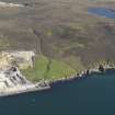
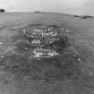
The crofting settlement comprised, in its final form, seven, conjoined, rectangular units built of drystone walling, all aligned NW-SE. The walls survive to 1.6m high in places and are generally c.1m wide. Internal floor areas range from 6.4 to 31.5 square metres. This settlement was abandoned about 1820. Associated features include a watermill (Structure 17 in the published report), a sheep-pen (Structure 16), a corn-drying kiln built over a teind barn (HU44NE 5.02) and four enclosures (Enclosures 4-7), one of which contained an area of rig (Cultivation Remains 6, see HU44NE 10).
No archaeological evidence of suspected Norse or early medieval occupation on the site was found.
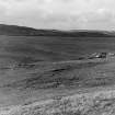
The remains of a small horizontal water mill were recorded at the base of the steep slope below the settlement, in a meander of the Burn of Kebister. It was rectangular, aligned NW-SE with drystone walls and an entrance in the centre of the NE wall. The water-channel, 1.4m wide, was located at the NW end of the building.The mill race forms a channel approximately 10m long on the S side of the mill.
The settlement is known to its present neighbours, living across the voe, as 'Handigert' (Willy and Mary Anderson pers comm), though this name never appears in the documentary sources and all those who lived in the township between 1577 and 1817 gave their address as Kebister.
O Owen and C Lowe 1999.
A township, comprising four unroofed buildings (see HU44NE 5 and HU44NE 14 ), one enclosure and a head-dyke is depicted on the 1st edition of the OS 6-inch map (Orkney and Shetland (Shetland) 1881, sheet liii). Six unroofed buildings and one enclosure are shown on the current edition of the OS 1:10000 map (1973).
Information from RCAHMS (AKK) 20 March 2001.
The excavation archive from Kebister has been catalogued. The archive consists of manuscripts, photographic material and drawings. Digital and audio archive is available and consists of drafts of the Kebister 1999 monograph, the stone catalogues, the key for the soil maps, mini data cartridges containing 'Kebister modified files' and a recorded conversation with Mr and Mrs Anderson.
Historic Scotland Archive Project (SW) 2001

