
Pricing Change
New pricing for orders of material from this site will come into place shortly. Charges for supply of digital images, digitisation on demand, prints and licensing will be altered.
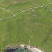
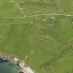
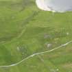
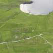
Unst, Underhoull


Farmstead (Norse)
Site Name Unst, Underhoull
Classification Farmstead (Norse)
Canmore ID 53
Site Number HP50SE 32
NGR HP 5755 0444
Datum OSGB36 - NGR
Permalink http://canmore.org.uk/site/53


- Council Shetland Islands
- Parish Unst
- Former Region Shetland Islands Area
- Former District Shetland
- Former County Shetland
HP50SE 32 5755 0444
At HP 5755 0448, on a gentle SE slope, are the turf-covered footings of a Norse farmstead measuring c.19.5m NW-SE by c.5.0m NE-SW. Virtually no stones protrude through the turf, so details of the walling cannot be ascertained, except that it appears to be quite substantial and the side walls are not straight. The remains of a cross-wall can be seen, and
the entrance is in the SE. Ground disturbance to the N and S of the building indicates two amorphous annexes and traces of field walls, probably contemporary, are visible.
Surveyed at 1/2500.
Visited by OS (NKB) 6 May 1969.

