 |
On-line Digital Images |
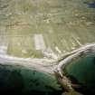
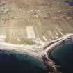
SC 991678 |
RCAHMS Aerial Photography |
Oblique aerial view centred on the factory, with the township and remains of the possible church adjacent, taken from the W. |
9/8/2005 |
Item Level |
|
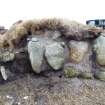 |
On-line Digital Images |
DP 102214 |
RCAHMS Field Survey Digital Photography |
Detail from SW showing settlement remains eroding from an exposed section. |
3/3/2010 |
Item Level |
|
 |
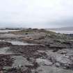
On-line Digital Images |
DP 102215 |
RCAHMS Field Survey Digital Photography |
View from NW showing settlement remains eroding from an exposed section. |
3/3/2010 |
Item Level |
|
 |
On-line Digital Images |
DP 102216 |
RCAHMS Field Survey Digital Photography |
General view from W. |
3/3/2010 |
Item Level |
|
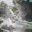 |
On-line Digital Images |
DP 235364 |
Historic Environment Scotland |
Oblique aerial view. |
2/6/2016 |
Item Level |
|
 |
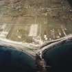
On-line Digital Images |
SC 1691223 |
RCAHMS Aerial Photography |
Oblique aerial view centred on the factory, with the township and remains of the possible church adjacent, taken from the W. |
9/8/2005 |
Item Level |
|
 |
On-line Digital Images |
SC 1691224 |
RCAHMS Aerial Photography |
Oblique aerial view centred on the factory, with the township and remains of the possible church adjacent, taken from the W. |
9/8/2005 |
Item Level |
|
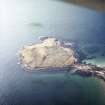 |
On-line Digital Images |
SC 1693899 |
RCAHMS Aerial Photography |
Oblique aerial view centred on the remains of the field banks, the lazy beds and the small cairns, taken from the SSE. |
9/8/2005 |
Item Level |
|
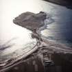 |
On-line Digital Images |
SC 1693900 |
RCAHMS Aerial Photography |
General oblique aerial view centred on the remains of the field banks, the lazy beds and the small cairns and possible dun, with the factory adjacent, taken from the E. |
9/8/2005 |
Item Level |
|
 |
On-line Digital Images |
SC 2356008 |
Records of the Ordnance Survey, Southampton, Hampshire, England |
South Uist, An Doirlinn, NF71NW 5, Ordnance Survey index card, Recto |
1958 |
Item Level |
|
 |
On-line Digital Images |
SC 2356009 |
Records of the Ordnance Survey, Southampton, Hampshire, England |
South Uist, An Doirlinn, NF71NW 5, Ordnance Survey index card, Recto |
1958 |
Item Level |
|


