 |
On-line Digital Images |
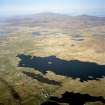
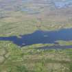
SC 991672 |
RCAHMS Aerial Photography |
General oblique aerial view looking across the township and the remains of the dun towards Dalabrog, and Beinn Mhor in the distance, taken from the SW. |
9/8/2005 |
Item Level |
|
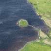 |
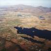
On-line Digital Images |
DP 235363 |
Historic Environment Scotland |
Oblique aerial view. |
2/6/2016 |
Item Level |
|
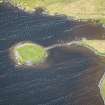 |
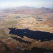
On-line Digital Images |
DP 235618 |
Historic Environment Scotland |
Oblique aerial view. |
3/6/2016 |
Item Level |
|
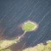 |
On-line Digital Images |
DP 235619 |
Historic Environment Scotland |
Oblique aerial view. |
3/6/2016 |
Item Level |
|
 |
On-line Digital Images |
DP 235763 |
Historic Environment Scotland |
Oblique aerial view. |
3/6/2016 |
Item Level |
|
 |
On-line Digital Images |
SC 1691014 |
RCAHMS Aerial Photography |
General oblique aerial view looking across the township and the remains of the dun towards Dalabrog, and Beinn Mhor in the distance, taken from the SW. |
9/8/2005 |
Item Level |
|
 |
On-line Digital Images |
SC 1691015 |
RCAHMS Aerial Photography |
General oblique aerial view looking across the township and the remains of the dun towards Dalabrog, and Beinn Mhor in the distance, taken from the SW. |
9/8/2005 |
Item Level |
|
 |
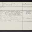
On-line Digital Images |
SC 2356002 |
Records of the Ordnance Survey, Southampton, Hampshire, England |
South Uist, Eilean Chreamh, NF71NW 2, Ordnance Survey index card, Recto |
1958 |
Item Level |
|
 |
On-line Digital Images |
SC 2356003 |
Records of the Ordnance Survey, Southampton, Hampshire, England |
South Uist, Eilean Chreamh, NF71NW 2, Ordnance Survey index card, Recto |
1958 |
Item Level |
|


