 |
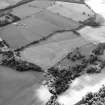
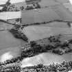
On-line Digital Images |
DP 013341 |
RCAHMS Aerial Photography Digital |
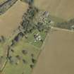
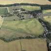
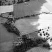
General oblique aerial view centred on the churches and burial-ground with the country house, school, farmhouse and farmsteading adjacent, taken from the SW. |
4/4/2006 |
Item Level |
|
 |
On-line Digital Images |
DP 013342 |
RCAHMS Aerial Photography Digital |
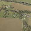
General oblique aerial view centred on the churches and burial-ground with the country house, school, farmhouse and farmsteading adjacent, taken from the SSE. |
4/4/2006 |
Item Level |
|
 |
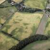
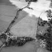
On-line Digital Images |
DP 019823 |
RCAHMS Aerial Photography Digital |
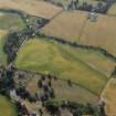
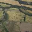
Oblique aerial view centred on the cropmarks of the possible enclosures with the church, burial-ground, manse and cropmarks of the pit-alignments adjacent, taken from the NW. |
27/7/2006 |
Item Level |
|
 |
On-line Digital Images |
DP 019824 |
RCAHMS Aerial Photography Digital |
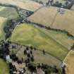
Oblique aerial view centred on the cropmarks of the possible enclosures with the church, burial-ground, manse and cropmarks of the pit-alignments adjacent, taken from the NW. |
27/7/2006 |
Item Level |
|
 |
On-line Digital Images |
DP 019825 |
RCAHMS Aerial Photography Digital |
Oblique aerial view centred on the cropmarks of the possible enclosures with the church, burial-ground, manse and cropmarks of the pit-alignments adjacent, taken from the SSE. |
27/7/2006 |
Item Level |
|
 |
On-line Digital Images |
DP 019826 |
RCAHMS Aerial Photography Digital |
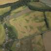
Oblique aerial view centred on the cropmarks of the pit-alignments with the church, burial-ground, manse and cropmarks of the possible enclosure adjacent, taken from the SE. |
27/7/2006 |
Item Level |
|
 |
On-line Digital Images |
DP 019827 |
RCAHMS Aerial Photography Digital |
Oblique aerial view centred on the cropmarks of the pit-alignments with the church, burial-ground, manse and cropmarks of the possible enclosure adjacent, taken from the S. |
27/7/2006 |
Item Level |
|
 |
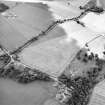
On-line Digital Images |
DP 019828 |
RCAHMS Aerial Photography Digital |
General oblique aerial view centred on the cropmarks of the pit-alignments and possible enclosure and the church, burial-ground and manse, taken from the NE. |
27/7/2006 |
Item Level |
|
 |
On-line Digital Images |
DP 019829 |
RCAHMS Aerial Photography Digital |
Oblique aerial view centred on the cropmarks of the pit-alignments with the church, burial-ground, manse and cropmarks of the possible enclosure adjacent, taken from the NE. |
27/7/2006 |
Item Level |
|
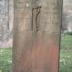 |
On-line Digital Images |
SC 1356679 |
Papers of Betty Willsher, historian, St Andrews, Scotland |
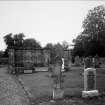
View of headstone to John Blackadder d. 1928 and Anna Wilson d. 1946 with tree of life, Edrom Parish Churchyard. |
c. 1970 |
Item Level |
|
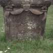 |
On-line Digital Images |
SC 1356680 |
Papers of Betty Willsher, historian, St Andrews, Scotland |
View of headstone dated August 1733 with possible Green Man, Edrom Parish Churchyard. |
c. 1970 |
Item Level |
|
 |
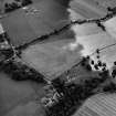
On-line Digital Images |
SC 1752108 |
RCAHMS Aerial Photography |
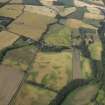
Oblique aerial view centred on the cropmarks of the possible enclosures and linear cropmarks with the church, burial ground, manse, country house, lodge, school, farmhouses, farmsteadings and cottages adjacent, taken from the NE. |
24/7/2003 |
Item Level |
|
 |
On-line Digital Images |
SC 1752109 |
RCAHMS Aerial Photography |
Oblique aerial view centred on the cropmarks of the possible enclosures and linear cropmarks with the church, burial ground, manse, country house, lodge, school, farmhouses, farmsteadings and cottages adjacent, taken from the NNE. |
24/7/2003 |
Item Level |
|
 |
On-line Digital Images |
SC 1752110 |
RCAHMS Aerial Photography |
Oblique aerial view centred on the possible enclosures and linear cropmarks with the church, burial ground, lodge, school, farmhouses, farmsteadings and cottages adjacent, taken from the ENE. |
24/7/2003 |
Item Level |
|
 |
On-line Digital Images |
SC 1752111 |
RCAHMS Aerial Photography |
Oblique aerial view centred on the possible enclosures and linear cropmarks with the church, burial ground, lodge, school, farmhouses, farmsteadings and cottages adjacent, taken from the ENE. |
24/7/2003 |
Item Level |
|
 |
On-line Digital Images |
SC 1752112 |
RCAHMS Aerial Photography |
Oblique aerial view centred on the possible enclosures and linear cropmarks with the church, burial ground, manse, lodge, school, farmhouses, farmsteadings and cottages adjacent, taken from the NE. |
24/7/2003 |
Item Level |
|
 |
On-line Digital Images |
SC 1752113 |
RCAHMS Aerial Photography |
Oblique aerial view centred on the possible enclosures and linear cropmarks with the church, burial ground, manse, lodge, school, farmhouses, farmsteadings and cottages adjacent, taken from the NNE. |
24/7/2003 |
Item Level |
|
 |
On-line Digital Images |
SC 2482367 |
Records of Historic Scotland, Edinburgh, Scotland |
General view from E. |
|
Item Level |
|


