 |
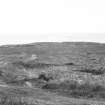
On-line Digital Images |
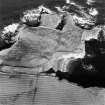
SC 981477 |
RCAHMS Aerial Photography |
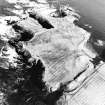
Oblique aerial view of the remains of the fort, chapel, harbour and rig, St john's Point, taken from the S. |
14/3/2002 |
Item Level |
|
 |
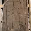
On-line Digital Images |
DP 086686 |
Records of the Royal Commission on the Ancient and Historical Monuments of Scotland (RCAHMS), Edinbu |
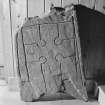
View of cross slab |
24/8/2010 |
Item Level |
|
 |
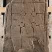
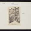
On-line Digital Images |
DP 086687 |
Records of the Royal Commission on the Ancient and Historical Monuments of Scotland (RCAHMS), Edinbu |
View of cross slab (with scale) |
24/8/2010 |
Item Level |
|
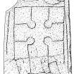 |
On-line Digital Images |
SC 1360245 |
Records of the Royal Commission on the Ancient and Historical Monuments of Scotland (RCAHMS), Edinbu |
Scanned ink drawing of St John's Chapel, Canisbay cross slab |
11/2010 |
Item Level |
|
 |
On-line Digital Images |
SC 1610196 |
Tom and Sybil Gray |
View of face of cross slab from St. John's Point in Canisbay, now in John Nicolson Museum, Auckengill. |
22/5/1991 |
Item Level |
|
 |
On-line Digital Images |
SC 1693789 |
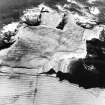
RCAHMS Aerial Photography |
Oblique aerial view of the remains of the fort, chapel, harbour and rig, taken from the SW. |
14/3/2002 |
Item Level |
|
 |
On-line Digital Images |
SC 1693790 |
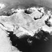
RCAHMS Aerial Photography |
Oblique aerial view of the remains of the fort, chapel, harbour and rig, taken from the S. |
14/3/2002 |
Item Level |
|
 |
On-line Digital Images |
SC 1693791 |
RCAHMS Aerial Photography |
Oblique aerial view of the remains of the fort, chapel, harbour and rig, taken from the SE. |
14/3/2002 |
Item Level |
|
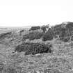 |
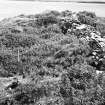
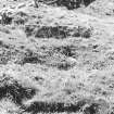
On-line Digital Images |
SC 1923733 |
|
Exterior of rampart. |
1971 |
Item Level |
|
 |
On-line Digital Images |
SC 1923734 |
|
Corner of Chapel. |
1971 |
Item Level |
|
 |
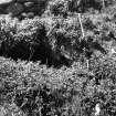
On-line Digital Images |
SC 1923735 |
|
Rear of rampart, pole is in corner of 'chapel'. |
1971 |
Item Level |
|
 |
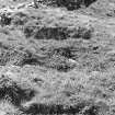
On-line Digital Images |
SC 1923736 |
|
Line of rampart, around fort. |
1971 |
Item Level |
|
 |
On-line Digital Images |
SC 1923737 |
|
Rear of rampart with 'chape'. |
1971 |
Item Level |
|
 |
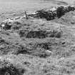
On-line Digital Images |
SC 1923743 |
|
St John's Point Fort (probable) chapel, exterior of rampart (ND 3105 7515) |
1971 |
Item Level |
|
 |
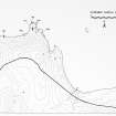
On-line Digital Images |
SC 1926335 |
Caithness Coastal Survey |
General survey area plan. |
1982 |
Item Level |
|
 |
On-line Digital Images |
SC 1926337 |
Caithness Coastal Survey |
Canisbay (West) Map |
1982 |
Item Level |
|
 |
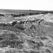
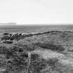
On-line Digital Images |
SC 1926404 |
Caithness Coastal Survey |
General view of site |
1980 |
Item Level |
|
 |
On-line Digital Images |
SC 1943533 |
Caithness Coastal Survey |
General view of site |
1980 |
Item Level |
|
 |
On-line Digital Images |
SC 1943694 |
Caithness Coastal Survey |
General view of site |
1980 |
Item Level |
|
 |
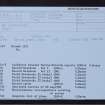
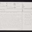
On-line Digital Images |
SC 2355034 |
Records of the Ordnance Survey, Southampton, Hampshire, England |
St John's Point, ND37NW 2, Ordnance Survey index card, page number 2, Verso |
c. 1958 |
Item Level |
|
 |
On-line Digital Images |
SC 2355035 |
Records of the Ordnance Survey, Southampton, Hampshire, England |
St John's Point, ND37NW 2, Ordnance Survey index card, page number 3, Recto |
c. 1958 |
Item Level |
|
 |
On-line Digital Images |
SC 2355036 |
Records of the Ordnance Survey, Southampton, Hampshire, England |
St John's Point, ND37NW 2, Ordnance Survey index card, Recto |
c. 1958 |
Item Level |
|
 |
On-line Digital Images |
SC 2355037 |
Records of the Ordnance Survey, Southampton, Hampshire, England |
St John's Point, ND37NW 2, Ordnance Survey index card, Recto |
c. 1958 |
Item Level |
|
 |
On-line Digital Images |
SC 2563345 |
Records of the Ordnance Survey, Southampton, Hampshire, England |
St John's Point, ND37SW 2, Ordnance Survey index card, Page Number 1, Recto |
c. 1958 |
Item Level |
|


