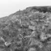
 |
On-line Digital Images |
SC 1923726 |
|
|
1971 |
Item Level |
|
 |
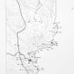
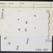
On-line Digital Images |
SC 1926335 |
Caithness Coastal Survey |
General survey area plan. |
1982 |
Item Level |
|
 |
On-line Digital Images |
SC 1926338 |
Caithness Coastal Survey |
Canisbay (East) Map |
1982 |
Item Level |
|
 |
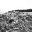
On-line Digital Images |
SC 1943727 |
Caithness Coastal Survey |
Stones outside broch. |
1980 |
Item Level |
|
 |
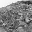
On-line Digital Images |
SC 1943728 |
Caithness Coastal Survey |
Stones outside broch. |
1980 |
Item Level |
|
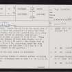 |
On-line Digital Images |
SC 2354804 |
Records of the Ordnance Survey, Southampton, Hampshire, England |
Rushy Geo, ND36NE 18, Ordnance Survey index card, page number 1, Recto |
c. 1958 |
Item Level |
|
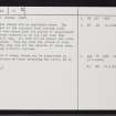 |
On-line Digital Images |
SC 2354805 |
Records of the Ordnance Survey, Southampton, Hampshire, England |
Rushy Geo, ND36NE 18, Ordnance Survey index card, page number 2, Verso |
c. 1958 |
Item Level |
|
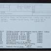 |
On-line Digital Images |
SC 2354806 |
Records of the Ordnance Survey, Southampton, Hampshire, England |
Rushy Geo, ND36NE 18, Ordnance Survey index card, Recto |
c. 1958 |
Item Level |
|
 |
On-line Digital Images |
SC 2354807 |
Records of the Ordnance Survey, Southampton, Hampshire, England |
Rushy Geo, ND36NE 18, Ordnance Survey index card, Recto |
c. 1958 |
Item Level |
|


