 |
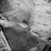
On-line Digital Images |
SC 1693538 |
RCAHMS Aerial Photography |
Oblique aerial view. |
1991 |
Item Level |
|
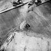 |
On-line Digital Images |
SC 1693539 |
RCAHMS Aerial Photography |
Oblique aerial view. |
1991 |
Item Level |
|
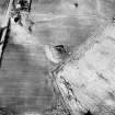 |
On-line Digital Images |
SC 1782697 |
RCAHMS Aerial Photography |
Oblique aerial view. |
1991 |
Item Level |
|
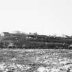 |
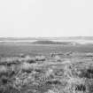
On-line Digital Images |
SC 1925901 |
|
View from S |
1983 |
Item Level |
|
 |
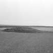
On-line Digital Images |
SC 1925902 |
|
View from W |
1983 |
Item Level |
|
 |
On-line Digital Images |
SC 1926335 |
Caithness Coastal Survey |
General survey area plan. |
1982 |
Item Level |
|
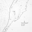 |
On-line Digital Images |
SC 1926343 |
Caithness Coastal Survey |
Wick (South) Map |
1982 |
Item Level |
|
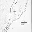 |
On-line Digital Images |
SC 1926344 |
Caithness Coastal Survey |
Wick (South) Map |
1982 |
Item Level |
|
 |
On-line Digital Images |
SC 1926666 |
Caithness Coastal Survey |
|
1981 |
Item Level |
|
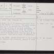 |
On-line Digital Images |
SC 2354144 |
Records of the Ordnance Survey, Southampton, Hampshire, England |
Borrowston, ND34SW 8, Ordnance Survey index card, page number 1, Recto |
c. 1958 |
Item Level |
|
 |
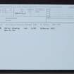
On-line Digital Images |
SC 2354145 |
Records of the Ordnance Survey, Southampton, Hampshire, England |
Borrowston, ND34SW 8, Ordnance Survey index card, Recto |
c. 1958 |
Item Level |
|
 |
On-line Digital Images |
SC 2354146 |
Records of the Ordnance Survey, Southampton, Hampshire, England |
Borrowston, ND34SW 8, Ordnance Survey index card, Recto |
c. 1958 |
Item Level |
|


