 |
On-line Digital Images |
DP 115471 |
RCAHMS Aerial Photography Digital |
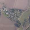
Oblique aerial view of Forteviot village, looking NNW. |
22/3/2012 |
Item Level |
|
 |
On-line Digital Images |
SC 1705539 |
|
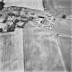
Forteviot, oblique aerial view, taken from the SSE, centred on cropmarks including those of an enclosure, a barrow cemetery and pit-alignments. Forteviot village is visible in the top half of the photograph. |
12/7/1996 |
Item Level |
|
 |
On-line Digital Images |
SC 1705540 |
|
Forteviot, oblique aerial view, taken from the ESE, centred on cropmarks including those of an enclosure, a barrow cemetery and pit-alignments. Forteviot village is visible in the top right-hand corner of the photograph. |
12/7/1996 |
Item Level |
|
 |
On-line Digital Images |
SC 1705541 |
|
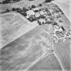
Forteviot, oblique aerial view, taken from the ENE, centred on cropmarks including those of an enclosure, a barrow cemetery and pit-alignments. Farm of Forteviot and Forteviot Manse are visible in the right half of the photograph. |
12/7/1996 |
Item Level |
|
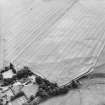 |
On-line Digital Images |
SC 1705552 |
RCAHMS Aerial Photography |
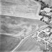
Oblique aerial view centred on the cropmarks of the enclosures with the manse adjacent, taken from the W. |
30/7/2001 |
Item Level |
|
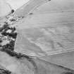 |
On-line Digital Images |
SC 1705554 |
RCAHMS Aerial Photography |
Oblique aerial view centred on the cropmarks of the enclosures with the manse adjacent, taken from the WSW. |
30/7/2001 |
Item Level |
|
 |
On-line Digital Images |
SC 2394160 |
Records of the Ordnance Survey, Southampton, Hampshire, England |
Forteviot, Greylag House, NO01NE 40, Ordnance Survey index card, Recto |
1958 |
Item Level |
|


