|
Photographs and Off-line Digital Images |
E 95342 PO |
Tom and Sybil Gray |
View of outline of houses
NMRS Survey of Private Collections |
14/10/1976 |
Item Level |
|
|
Photographs and Off-line Digital Images |
E 95344 PO |
Tom and Sybil Gray |
View of long house looking into entrance showing some pillars
NMRS Survey of Private Collections |
14/10/1976 |
Item Level |
|
|
Photographs and Off-line Digital Images |
E 95345 PO |
Tom and Sybil Gray |
View of long house from North towards entrance
NMRS Survey of Private Collections |
14/10/1976 |
Item Level |
|
|
Photographs and Off-line Digital Images |
E 95346 PO |
Tom and Sybil Gray |
View of longhouse
NMRS Survey of Private Collections |
14/10/1976 |
Item Level |
|
|
Photographs and Off-line Digital Images |
E 95347 PO |
Tom and Sybil Gray |
View of entrance
NMRS Survey of Private Collections |
14/10/1976 |
Item Level |
|
|
Photographs and Off-line Digital Images |
E 95348 PO |
Tom and Sybil Gray |
View of round huts with interconnecting passages
NMRS Survey of Private Collections |
14/10/1976 |
Item Level |
|
|
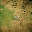
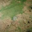
Photographs and Off-line Digital Images |
E 40799 CN |
RCAHMS Aerial Photography |
Oblique aerial view centred on the remains of the dun, settlement and field system with hut-circle and farmstead adjacent, taken from the NE. |
28/4/2004 |
Item Level |
|
|
Photographs and Off-line Digital Images |
E 40800 CN |
RCAHMS Aerial Photography |
Oblique aerial view centred on the remains of the dun, settlement and field system with hut-circle and farmstead adjacent, taken from the NW. |
28/4/2004 |
Item Level |
|
|
Photographs and Off-line Digital Images |
E 40801 CN |
RCAHMS Aerial Photography |
Oblique aerial view centred on the remains of the dun, settlement and field system with hut-circle and farmstead adjacent, taken from the W. |
28/4/2004 |
Item Level |
|
|
Photographs and Off-line Digital Images |
E 43668 |
RCAHMS Aerial Photography |
Oblique aerial view centred on the remains of the dun, settlement and field system with hut-circle and farmstead adjacent, taken from the WSW. |
28/4/2004 |
Item Level |
|
|
Photographs and Off-line Digital Images |
E 43672 |
RCAHMS Aerial Photography |
Oblique aerial view centred on the remains of the dun, settlement and field system with hut-circle and farmstead adjacent, taken from the NNW. |
28/4/2004 |
Item Level |
|
|
Photographs and Off-line Digital Images |
E 43673 |
RCAHMS Aerial Photography |
Oblique aerial view centred on the remains of the dun, settlement and field system with hut-circle and farmstead adjacent, taken from the WNW. |
28/4/2004 |
Item Level |
|
|
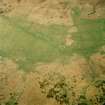
Photographs and Off-line Digital Images |
E 40802 CN |
RCAHMS Aerial Photography |
Oblique aerial view centred on the remains of the farmstead and field system with dun, settlement, hut-circle and burnt mounds adjacent, taken from the W. |
28/4/2004 |
Item Level |
|
|
Photographs and Off-line Digital Images |
E 40803 CN |
RCAHMS Aerial Photography |
Oblique aerial view centred on the remains of the dun and settlement with field system and hut circle adjacent, taken from the WSW. |
28/4/2004 |
Item Level |
|
|
Photographs and Off-line Digital Images |
E 40804 CN |
RCAHMS Aerial Photography |
Oblique aerial view centred on the remains of the farmstead and field system with dun, settlement and burnt mounds adjacent, taken from the SSE. |
28/4/2004 |
Item Level |
|
|
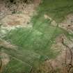
Photographs and Off-line Digital Images |
E 40805 CN |
RCAHMS Aerial Photography |
Oblique aerial view centred on the remains of the farmsteads, field system and burnt mounds, taken from the SE. |
28/4/2004 |
Item Level |
|
 |
On-line Digital Images |
SC 970392 |
RCAHMS Aerial Photography |
Oblique aerial view centred on the remains of the dun, settlement and field system with hut-circle and farmstead adjacent, taken from the NE. |
28/4/2004 |
Item Level |
|
 |
On-line Digital Images |
SC 970393 |
RCAHMS Aerial Photography |
Oblique aerial view centred on the remains of the farmstead and field system with dun, settlement, hut-circle and burnt mounds adjacent, taken from the W. |
28/4/2004 |
Item Level |
|
|
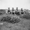
Photographs and Off-line Digital Images |
SC 973439 |
Records of the Society of Antiquaries of Scotland, Edinburgh, Scotland |
Excavation photograph. The team of workmen at the Wag. July 1946. |
1946 |
Item Level |
|
|
Photographs and Off-line Digital Images |
SC 973440 |
Records of the Society of Antiquaries of Scotland, Edinburgh, Scotland |
Excavation photograph. Colonel McClintoch and the staff at Forse Wag, in 1947. Col. McClintoch and Simon Bremner indicated. |
1947 |
Item Level |
|
 |
On-line Digital Images |
SC 975025 |
Records of the Society of Antiquaries of Scotland, Edinburgh, Scotland |
Excavation photograph. The Staff, July 1939. One figure marked with initials 'H I'. |
1939 |
Item Level |
|
 |
On-line Digital Images |
SC 1018700 |
RCAHMS Aerial Photography |
Oblique aerial view centred on the remains of the farmsteads, field system and burnt mounds, taken from the SE. |
28/4/2004 |
Item Level |
|
 |
On-line Digital Images |
SC 1018724 |
RCAHMS Aerial Photography |
Oblique aerial view centred on the remains of the dun, settlement and field system with hut-circle and farmstead adjacent, taken from the NW.
Digital copy of photograph. |
28/4/2004 |
Item Level |
|
|
Photographs and Off-line Digital Images |
SC 1112158 |
Records of the Society of Antiquaries of Scotland, Edinburgh, Scotland |
Excavation, June 1948. View across paved area from south-east, showing inner part. |
1948 |
Item Level |
|


