 |
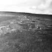
On-line Digital Images |
SC 1926333 |
Caithness Coastal Survey |
Maps of Latheron parish. Negative Available. |
1982 |
Item Level |
|
 |
On-line Digital Images |
SC 1926334 |
Caithness Coastal Survey |
Maps of Latheron parish. Negative Available. |
1982 |
Item Level |
|
 |
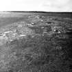
On-line Digital Images |
SC 1926335 |
Caithness Coastal Survey |
General survey area plan. |
1982 |
Item Level |
|
 |
On-line Digital Images |
SC 1926345 |
Caithness Coastal Survey |
Maps of Latheron parish |
1982 |
Item Level |
|
 |
On-line Digital Images |
SC 1943992 |
Caithness Coastal Survey |
|
1982 |
Item Level |
|
 |
On-line Digital Images |
SC 1943993 |
Caithness Coastal Survey |
|
1982 |
Item Level |
|
 |
On-line Digital Images |
SC 2353385 |
Records of the Ordnance Survey, Southampton, Hampshire, England |
Roy Geo, ND23NE 24, Ordnance Survey index card, Recto |
1958 |
Item Level |
|
 |
On-line Digital Images |
SC 2353386 |
Records of the Ordnance Survey, Southampton, Hampshire, England |
Roy Geo, ND23NE 24, Ordnance Survey index card, Recto |
1958 |
Item Level |
|


