
Knockinnon Castle


Building (Period Unassigned), Castle (Medieval)
Site Name Knockinnon Castle
Classification Building (Period Unassigned), Castle (Medieval)
Alternative Name(s) Knock Innon Castle
Canmore ID 8200
Site Number ND13SE 9
NGR ND 1807 3150
Datum OSGB36 - NGR
Permalink http://canmore.org.uk/site/8200


- Council Highland
- Parish Latheron
- Former Region Highland
- Former District Caithness
- Former County Caithness
ND13SE 9 1807 3150.
(ND 1807 3150) Knock Innon - Supposed Remains of (NAT) Castle (NR)
OS 6" map, Caithness, 1st ed., (1871)
Knockinnan Castle (NR) (remains of)
OS 1:10,000 map, (1979)
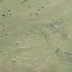
Knock Innon: supposed remains of castle. A very prominent hill near the county road from Wick to the S, on which there are the foundations of extensive buildings. Believed locally to have been the site of a church or chapel, at any rate the parish school was at one time on this hill. Perhaps it may be the site of the Castle of Cnocinnon.
Name Book 1872.
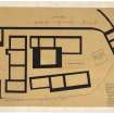
Knockinnan Castle is said to have been begun early in the 16th century, and left unfinished after the battle of Flodden in 1513. It is not easy to say what the building was like when it was entire and the plan is in part conjectural due to the severely ruined nature of the remaining walls. There seems to have been a central keep with thick walls, and numerous extensive buildings forming a double courtyard - the whole surrounded with a wall rising from the edge of a cliff up to 7ft in height. There appears to be no historical reference to it.
Macfarlane (1906-8) adds (from a description of the parish about 1726) that 'at the place designed for the entry to this great building, there was a large broad causeway begun and it is reported that that causeway was carried on to the town of Thurso. That part which was made in the Causeway mire (ND 164 496) is obvious to any who travel that way'.
D MacGibbon and T Ross 1887-92; W Macfarlane 1906-8; RCAHMS 1911.
The turf-covered remains of a castle situated on the summit of a hill known locally as Cnoc Heara, as described and illustrated by MacGibbon and Ross. The footings of a building, some 17.0 by 4.2m, on a flat spur to the S of the castle, may be the remains of the parish school.
Resurveyed at 1:2500.
Visited by OS (N K B) 25 March 1968.
No change to the previous field report except that the suggested remains of the parish school are probably the footings of a traditional crofting long-house.
Visited by OS (J M) 13 October 1982.

