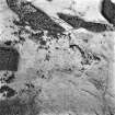
 |
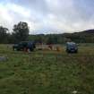
On-line Digital Images |
DP 171864 |
RCAHMS Field Survey Digital Photography |
General shot. |
10/10/2013 |
Item Level |
|
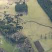 |
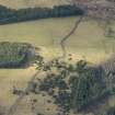
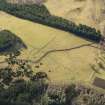
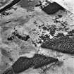
On-line Digital Images |
DP 204788 |
RCAHMS Aerial Photography Digital |
Oblique aerial view of Dunachtonmore clearance cairns and township, looking SW. |
14/4/2014 |
Item Level |
|
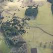 |
On-line Digital Images |
DP 204789 |
RCAHMS Aerial Photography Digital |
Oblique aerial view of Dunachtonmore clearance cairns and township, looking SSW. |
14/4/2014 |
Item Level |
|
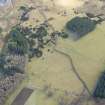 |
On-line Digital Images |
DP 204790 |
RCAHMS Aerial Photography Digital |
Oblique aerial view of Dunachtonmore clearance cairns and township, looking S. |
14/4/2014 |
Item Level |
|
 |
On-line Digital Images |
DP 204791 |
RCAHMS Aerial Photography Digital |
Oblique aerial view of Dunachtonmore clearance cairns and township, looking NW. |
14/4/2014 |
Item Level |
|
 |
On-line Digital Images |
DP 204792 |
RCAHMS Aerial Photography Digital |
Oblique aerial view of Dunachtonmore clearance cairns and township, looking SSW. |
14/4/2014 |
Item Level |
|
 |
On-line Digital Images |
DP 204793 |
RCAHMS Aerial Photography Digital |
Oblique aerial view of Dunachtonmore clearance cairns and township, looking S. |
14/4/2014 |
Item Level |
|
 |
On-line Digital Images |
DP 204794 |
RCAHMS Aerial Photography Digital |
Oblique aerial view of Dunachtonmore clearance cairns, township and Dunachtonmore Farm, looking SSW. |
14/4/2014 |
Item Level |
|
 |
On-line Digital Images |
DP 204795 |
RCAHMS Aerial Photography Digital |
Oblique aerial view of Dunachtonmore clearance cairns and township, looking W. |
14/4/2014 |
Item Level |
|
 |
On-line Digital Images |
DP 204796 |
RCAHMS Aerial Photography Digital |
Oblique aerial view of Dunachtonmore clearance cairns and township, looking W. |
14/4/2014 |
Item Level |
|
 |
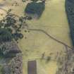
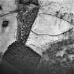
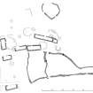
On-line Digital Images |
SC 1463683 |
Records of the Royal Commission on the Ancient and Historical Monuments of Scotland (RCAHMS), Edinbu |
RCAHMS survey drawing: Dunachtonmore, plan of township |
6/2013 |
Item Level |
|
 |
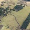
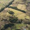
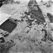
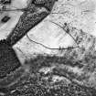
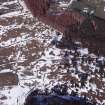
On-line Digital Images |
SC 1696274 |
RCAHMS Aerial Photography |
Dunachtonmore, oblique aerial view, taken from the SW, centred on a farmstead, and showing a township and field clearance cairns in the top left-hand corner of the photograph. |
9/2/1995 |
Item Level |
|
 |
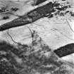
On-line Digital Images |
SC 1696275 |
RCAHMS Aerial Photography |
Dunachtonmore, oblique aerial view, taken from the SW, centred on a farmstead, and showing a township and field clearance cairns in the top left-hand corner of the photograph. |
9/2/1995 |
Item Level |
|
 |
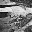
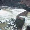
On-line Digital Images |
SC 1696276 |
RCAHMS Aerial Photography |
Dunachtonmore, oblique aerial view, taken from the SSW, centred on a farmstead, and showing a township, field clearance cairns and another farmstead in the top half of the photograph. |
9/2/1995 |
Item Level |
|
 |
On-line Digital Images |
SC 1696277 |
RCAHMS Aerial Photography |
Dunachtonmore, oblique aerial view, taken from the S, centred on a farmstead, and showing a township, field clearance cairns and another farmstead in the top half of the photograph. |
9/2/1995 |
Item Level |
|
 |
On-line Digital Images |
SC 1696278 |
RCAHMS Aerial Photography |
Dunachtonmore, oblique aerial view, taken from the SE, centred on a farmstead, a township and field clearance cairns. Another farmstead is visible in the foreground of the photograph. |
9/2/1995 |
Item Level |
|
 |
On-line Digital Images |
SC 1696279 |
RCAHMS Aerial Photography |
Dunachtonmore, oblique aerial view, taken from the E, centred on a farmstead and field clearance cairns. Another farmstead is visible in the top right-hand corner of the photograph. |
9/2/1995 |
Item Level |
|
 |
On-line Digital Images |
SC 1696280 |
RCAHMS Aerial Photography |
Dunachtonmore, oblique aerial view, taken from the NNE, centred on a township. Field clearance cairns are visible in the top half of the photograph. |
9/2/1995 |
Item Level |
|
 |
On-line Digital Images |
SC 1696281 |
RCAHMS Aerial Photography |
Dunachtonmore, oblique aerial view, taken from the NNW, centred on a township. Field clearance cairns are visible in the top half of the photograph. |
9/2/1995 |
Item Level |
|
 |
On-line Digital Images |
SC 1696282 |
RCAHMS Aerial Photography |
Dunachtonmore, oblique aerial view, taken from the NW, centred on township remains and field clearance cairns. Farmsteads are visible in the top right-hand corner of the photograph. |
9/2/1995 |
Item Level |
|
 |
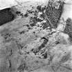
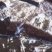
On-line Digital Images |
SC 1944713 |
Papers of James Sloan Bone, landscape historian, Inverness, Highland, Scotland |
Aerial view of township remains, Dunachtonmore Farm, Kincraig, Badenoch & Strathspey, looking N. |
24/4/2000 |
Item Level |
|
 |
On-line Digital Images |
SC 1944716 |
Papers of James Sloan Bone, landscape historian, Inverness, Highland, Scotland |
Aerial view of sheepwash & township remains, W of Dunachtonmore Farm, Kincraig, Badenoch & Strathspey, looking W. |
27/4/2000 |
Item Level |
|
 |
On-line Digital Images |
SC 1967455 |
Papers of James Sloan Bone, landscape historian, Inverness, Highland, Scotland |
Aerial view of township remains and farm, Dunachtonmore, S of Kincraig, Badenoch, looking NNW. |
29/2/1996 |
Item Level |
|
 |
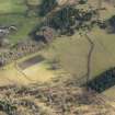
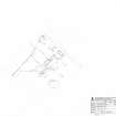
On-line Digital Images |
SC 2121938 |
Records of the Royal Commission on the Ancient and Historical Monuments of Scotland (RCAHMS), Edinbu |
Dunachtonmore, 1:500 plan of township |
7/2013 |
Item Level |
|


