|
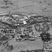
Photographs and Off-line Digital Images |
D 9311 |
RCAHMS Aerial Photography |
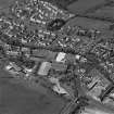
Aerial view of Newmilns railway viaduct and factories, centred on the site of Greenhead Mills, taken from the SSW. |
30/5/1997 |
Item Level |
|
|
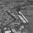
Photographs and Off-line Digital Images |
D 9312 |
RCAHMS Aerial Photography |
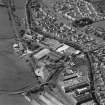
Aerial view of Newmilns railway viaduct and factories, taken from the SE and centred on Greenhead Mills, including the site of Darvel Road Hosiery Works. |
30/5/1997 |
Item Level |
|
|
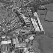
Photographs and Off-line Digital Images |
D 9313 |
RCAHMS Aerial Photography |
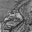
Aerial view of Newmilns railway viaduct and factories, centred on the site of Greenhead Mills, taken from the SE. |
30/5/1997 |
Item Level |
|
|
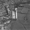
Photographs and Off-line Digital Images |
D 9314 |
RCAHMS Aerial Photography |
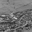
Aerial view of Newmilns railway viaduct and factories, centred on the site of Greenhead Mills, taken from the NE. |
30/5/1997 |
Item Level |
|
|
Photographs and Off-line Digital Images |
D 9309 |
RCAHMS Aerial Photography |
Aerial view of Newmilns railway viaduct and factories, centred on Union Street Factory, taken from the NNW. |
30/5/1997 |
Item Level |
|
|
Photographs and Off-line Digital Images |
D 9315 |
RCAHMS Aerial Photography |
General aerial view of Newmilns railway viaduct and factories, centred on the site of Greenhead Mills, taken from the E. |
30/5/1997 |
Item Level |
|
|
Photographs and Off-line Digital Images |
D 9316 |
RCAHMS Aerial Photography |
General aerial view of Newmilns railway viaduct and factories, centred on the site of Greenhead Mills, taken from the ENE. |
30/5/1997 |
Item Level |
|
|
Photographs and Off-line Digital Images |
D 9317 |
RCAHMS Aerial Photography |
General aerial view of Newmilns railway viaduct and factories, centred on the site of Greenhead Mills, taken from the NE. |
30/5/1997 |
Item Level |
|
|
Photographs and Off-line Digital Images |
D 9318 |
RCAHMS Aerial Photography |
General aerial view of Newmilns and Greenholm, taken from the NW. |
30/5/1997 |
Item Level |
|
|
Photographs and Off-line Digital Images |
D 9319 |
RCAHMS Aerial Photography |
General aerial view of Newmilns and Greenholm, taken from the WNW. |
30/5/1997 |
Item Level |
|
|
Photographs and Off-line Digital Images |
D 9320 |
RCAHMS Aerial Photography |
General aerial view of Newmilns and Greenholm, taken from the W. |
30/5/1997 |
Item Level |
|
|
Photographs and Off-line Digital Images |
D 9321 |
RCAHMS Aerial Photography |
General aerial view of Newmilns and Greenholm, taken from the WSW. |
30/5/1997 |
Item Level |
|
|
Photographs and Off-line Digital Images |
D 9322 |
RCAHMS Aerial Photography |
General aerial view of Newmilns, taken from the SW. |
30/5/1997 |
Item Level |
|
|
Print Room |
PA 20/18 |
General Collection. Photograph Albums. |
General view showing Lime Road Walk, Newmilns with ladies and pram.
PHOTOGRAPH ALBUM NO: 20 : LORETTO ALBUM |
c. 1870 |
Item Level |
|
|
Manuscripts |
MS 60 |
|
Lists of houses of historic interest compiled by I G Lindsay and the Marquess of Bute.
National Trust list index, 1940.
Provisional list of towns visited, 1936.
Lists and photocopied plans, 1936.
Original town maps, 1936. |
1936 |
Item Level |
|
|
Photographs and Off-line Digital Images |
B 78309 |
|
Photographic copy of postcard showing general view of Newilns from South. |
1902 |
Item Level |
|
 |
On-line Digital Images |
SC 1686704 |
RCAHMS Aerial Photography |
General aerial view of Stoneygate Road and Brown Street factories, including the railway bridge, taken from the SSE. |
30/5/1997 |
Item Level |
|
 |
On-line Digital Images |
SC 1686705 |
RCAHMS Aerial Photography |
General aerial view of Stoneygate Road and Brown Street factories, including the railway bridge, taken from the E. |
30/5/1997 |
Item Level |
|
 |
On-line Digital Images |
SC 1686706 |
RCAHMS Aerial Photography |
General aerial view of Stoneygate Road and Brown Street factories, including the railway bridge, taken from the NE. |
30/5/1997 |
Item Level |
|
 |
On-line Digital Images |
SC 1686707 |
RCAHMS Aerial Photography |
General aerial view of Stoneygate Road and Brown Street factories, taken from the NE. |
30/5/1997 |
Item Level |
|
 |
On-line Digital Images |
SC 1686708 |
RCAHMS Aerial Photography |
General aerial view of Stoneygate Road and Brown Street factories, taken from the N. |
30/5/1997 |
Item Level |
|
 |
On-line Digital Images |
SC 1686709 |
RCAHMS Aerial Photography |
General aerial view of Brown Street factories and railway bridge, taken from the WSW. |
30/5/1997 |
Item Level |
|
 |
On-line Digital Images |
SC 1686710 |
RCAHMS Aerial Photography |
General aerial view of Brown Street factories and railway bridge, taken from the WSW. |
30/5/1997 |
Item Level |
|
 |
On-line Digital Images |
SC 1686711 |
RCAHMS Aerial Photography |
General aerial view of Brown Street factories and railway bridge, taken from the SW. |
30/5/1997 |
Item Level |
|


